
Business Details
21 Years
experience
Expert Land Surveying Services in TN & NC
Appalachian Surveying Consultants was established in December 2005 to provide expert land surveying and development planning services across Eastern Tennessee and Western North Carolina. Our team brings over two decades of specialized experience in boundary surveys, topographic mapping, construction staking, and floodplain certification, addressing the unique challenges of mountainous terrain. We prioritize precision and client collaboration, utilizing advanced GPS and CAD technologies to deliver tailored solutions. Our president personally oversees projects to ensure alignment with client visions, supported by a commitment to professional standards through memberships in NSPS, TAPS, and NCSS.With a track record managing over $1 billion in residential and commercial developments, we combine technical expertise with local knowledge to meet diverse land planning needs. Our services extend to FEMA elevation certificates, subdivision plats, and ALTA surveys, backed by a promise of free project quotes and timely execution. As educators and practitioners, we maintain adjunct teaching roles at East Tennessee State University, reinforcing our dedication to advancing surveying excellence. This integrated approach ensures clients receive technically sound, ethically delivered results that transform land development concepts into reality.
Services
Boundary Surveys
Topographic Surveys
Construction Staking
Site Planning
Roadway Design
Grading Plans
Subdivision Planning
FEMA Certificates
ALTA Surveys
Aerial Mapping
Details
- Year established: 2005
Highlights and features
- We have over 20 years of experience in mountainous land surveying challenges
- Our president personally oversees all client projects from start to finish
- Free project quotes available for both large-scale and small local surveys
- Certified floodplain surveyors in both North Carolina and Tennessee
- Utilize the latest GPS and computer-aided design technology for precision
Services
Boundary Surveys
We conduct precise boundary surveys for residential and commercial land sales, establishing legal property lines using advanced GPS technology. Our surveys meet ALTA standards and include historical research to resolve potential disputes. Clients receive detailed documentation for title insurance and development planning purposes.
Topographic Surveys
Our topographic surveys create detailed elevation models for site planning and improvement locations. Using robotic total stations and GPS systems, we map natural and man-made features to support construction and permitting processes. Deliverables include contour maps and digital terrain models for engineering analysis.
Construction Staking
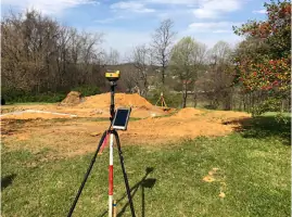
We provide accurate construction staking for residential foundations and commercial developments, marking building pads, utilities, and grading limits. Our team works with contractors to ensure proper alignment with approved plans, minimizing rework through real-time GPS verification.
FEMA Elevation Certificates
As certified floodplain surveyors in Tennessee and North Carolina, we prepare FEMA elevation certificates for Zones A and AE. Our E-Loma certified process secures approvals within one week, including LOMR-F applications and free flood risk analyses for property owners.
Subdivision Planning
We handle complete subdivision planning from boundary analysis to final platting, including roadway design and erosion control plans. Our team coordinates with local governments to ensure regulatory compliance, having successfully completed projects like the 72-lot Panthers Crossing community.
People
Mr. Bartlett
President
Founder with over 20 years of land surveying experience. Holds AAS in Civil Engineering, licensed in NC (L-3593) and TN (#1984). Former Surveying Manager at Cavanaugh & Associates and Chief Operations Officer at Mountain Brook LLC. Adjunct professor at East Tennessee State University since 2019.
Questions
What surveying services do you offer?
We provide boundary surveys, topographic mapping, construction staking, FEMA elevation certificates, subdivision plats, and ALTA surveys using GPS and robotic total stations.
Which areas do you serve?
Our primary service areas include Eastern Tennessee and Western North Carolina, covering both urban developments and mountainous regions.
How experienced is your team?
Our founder has over 30 years in surveying since 1989, with 20+ years managing $1B+ in residential and commercial developments across two states.
Do you provide free project estimates?
Yes, we offer free quotes for all projects regardless of size, from simple boundary checks to large-scale development surveys.
Are you certified for floodplain surveys?
Our team holds active certifications as floodplain surveyors in both North Carolina (NC-065) and Tennessee (TN-001).