
Business Details
We have been delivering integrated civil engineering and land surveying solutions in the DC Metro area for over 35 years. Our founder, Anthony Currie, combined his civil engineering background with years as a land surveyor to create a firm that unites these disciplines under one roof. We hold licensed and registered land surveying credentials in the District of Columbia, giving us unique access to local regulations and project requirements. We have successfully completed highprofile projects, including Nationals Park and numerous condo conversions, demonstrating our capacity for both largescale and detailed work. Our advanced technology, including robotic instruments, allows us to complete surveys in hours rather than days, ensuring timely delivery without sacrificing accuracy. We prioritize efficiency, accuracy, and affordability in every engagement, aligning our services with clients budgets and schedules.
We collaborate closely with owners, architects, contractors, and government agencies to provide precise data that informs design, zoning, and environmental compliance. We have a proven track record of managing environmental assessments, floodplain studies, and stormwater management plans that meet or exceed regulatory standards. We deliver comprehensive feasibility studies that help clients understand zoning, utilities, soil classification, and other factors critical to decisionmaking. Our commitment to client satisfaction is reflected in repeat business from architects, developers, and local government partners who trust us for every phase of their projects. We continue to invest in stateoftheart equipment and ongoing staff training to maintain the highest level of professional expertise and service quality.
We collaborate closely with owners, architects, contractors, and government agencies to provide precise data that informs design, zoning, and environmental compliance. We have a proven track record of managing environmental assessments, floodplain studies, and stormwater management plans that meet or exceed regulatory standards. We deliver comprehensive feasibility studies that help clients understand zoning, utilities, soil classification, and other factors critical to decisionmaking. Our commitment to client satisfaction is reflected in repeat business from architects, developers, and local government partners who trust us for every phase of their projects. We continue to invest in stateoftheart equipment and ongoing staff training to maintain the highest level of professional expertise and service quality.
Highlights and features
- We bring 35 years of DC civil engineering expertise.
- We are licensed and registered land surveyors in DC.
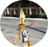
- We use robotic instruments for hourslong surveys.
- We integrate engineering and surveying for faster turnaround.
- We deliver precise boundary and ALTA surveys for developers.
Services
Site Planning
Our Site Planning service delivers accurate topographic, boundary, and ALTA surveys to inform design decisions. We serve architects, developers, and government agencies, ensuring precise data for construction, zoning, and floodplain analysis. Clients benefit from faster project approvals, reduced risk, and a reliable foundation for all subsequent phases.
Land Surveying
Our Land Surveying program translates project visions into precise site data. We collaborate closely with owners and architects to design water and sewer systems, conduct floodplain studies, and implement stormwater management. Clients gain accurate utilities mapping, erosion control insights, and compliance assurance for sustainable construction.
Environmental Assessments
Our Environmental Assessments ensure projects comply with local regulations and promote sustainability. We perform wetlands assessments, forest delineation studies, and comprehensive reporting to mitigate ecological impacts. Clients receive clear guidance on permits, mitigation strategies, and environmental stewardship for every development.
Feasibility Studies
Our Feasibility Studies assess zoning, utilities, soil, and other critical factors for project viability. We provide detailed analyses that guide acquisition decisions, design options, and risk mitigation. Clients benefit from informed budgeting, faster approvals, and a stronger foundation for investment.