Business Details
16 Years
experience
Expert Land Surveying Services in Hilo, HI
DLB & Associates was founded in August 2010 by Daniel L. Berg, a licensed professional land surveyor with over 30 years of experience in Hawaii and California. Our expertise spans boundary surveying, staking, subdivisions, and advanced mapping technologies, combining traditional methods with modern GPS and digital tools. We prioritize client education, delivering court-defensible solutions that clarify property rights through precise legal and technical analysis. Our mission focuses on providing accurate, aesthetically clear maps that reflect both physical and legal boundary considerations. Licensed in Hawaii (PLS 11245) and California (PLS 6318), we serve property owners, real estate professionals, and contractors with personalized service. We emphasize transparency, offering free quotes for all survey types while maintaining rigorous adherence to industry standards.Our team navigates complex land-use regulations to simplify processes for clients, ensuring compliance with local ordinances and federal requirements like FEMA elevation certifications. With a legacy of technological adaptation since 1984, we remain committed to evolving with the surveying professions advancements. Our Hilo-based operations extend across Hawaii County and California, supporting clients in resolving boundary disputes and planning developments. By integrating field data with legal research, we deliver solutions that balance scientific precision with practical application for residential, commercial, and governmental clients.
Services
Boundary Surveys
K-1 Staking Surveys
K-2 Staking Surveys
Subdivisions & Easements
Shoreline Surveys
FEMA Elevation Certs
Topographic Surveys
Construction Layout
Control Networks
Aerial Imagery
Details
- Year established: 2010
Highlights and features
- Over 30 years of experience in land surveying across Hawaii and California
- Licensed professionals in both Hawaii (PLS 11245) and California (PLS 6318)
- Free quotes provided for all surveying services
- Court-defensible boundary solutions combining legal and technical expertise
- Detailed aesthetic mapping to clarify property rights
Services
Boundary Surveys
Boundary Surveys establish property perimeters using legal descriptions, critical for real estate transactions or resolving disputes. Our process combines historical records with modern GPS technology to ensure accuracy. Clients receive detailed maps clarifying setbacks, easements, and ownership rights.
FEMA Elevation Certs
FEMA Elevation Certificates verify building compliance in flood zones, essential for insurance and permitting. We document precise elevation data relative to floodplain regulations, helping clients meet federal requirements and reduce insurance costs through accurate documentation.
Topographic Surveys
Topographic Surveys create 3D maps showing natural and man-made features with elevation changes. This detailed data supports construction planning, environmental assessments, and land development projects through comprehensive terrain analysis.
Construction Layout
Construction Layout translates building plans to physical markers, guiding contractors on foundation placements and utility locations. Our precise staking ensures projects adhere to approved designs while minimizing costly field adjustments during development.
Control Networks
Control Networks establish precise coordinate frameworks for large-scale projects. These reference systems ensure consistency across multiple survey phases, supporting infrastructure development and long-term monitoring with repeatable accuracy.
People
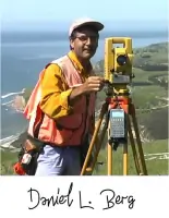
Daniel L. Berg
Owner
With over 30 years of experience since 1984, Daniel L. Berg is a licensed surveyor in Hawaii and California. He specializes in boundary resolution, combining legal expertise with technological innovation to deliver defensible land surveys.
Questions
What surveying services do you offer?
We provide boundary surveys, staking, subdivisions, shoreline surveys, FEMA elevation certificates, topographic surveys, construction layout, control networks, and aerial imagery services.
How can I request a quote?
Complete our online 'Request a Quote' form with property details or contact us directly via phone for a free consultation.
Are you licensed in Hawaii and California?
Yes, our owner Daniel L. Berg holds active licenses in both states (Hawaii PLS 11245 and California PLS 6318).
Do you serve areas outside Hawaii County?
While based in Hawaii County, we provide services statewide in Hawaii and California for various surveying needs.
What makes your boundary surveys unique?
We combine legal research, historical monument analysis, and modern technology to create court-defensible solutions with clear visual documentation.