Business Details
50+ Years
experience
Your Trusted Land Surveyors in Central Virginia
Saunders' Surveys has been a trusted name in land surveying, engineering, and land planning for over a century. Founded in 1915, our firm combines a century of historical expertise with cutting-edge technology to deliver precise and reliable surveying solutions. Our team specializes in boundary surveys, topographic mapping, site development, and construction stakeout, serving both residential and commercial clients across Central Virginia. With access to nearly 90% of original land plats and over 12,000 completed projects, we resolve boundary disputes efficiently and maintain an unparalleled archive of historical data. Our commitment to accuracy, client satisfaction, and preserving the legacy of our family-owned business ensures every project meets the highest standards of professionalism and integrity. We approach each task with a personalized strategy, assembling dedicated teams to guide projects from concept to completion.Our services extend to mortgage surveys, drainage planning, and specialized projects like athletic facility design and cemetery mapping, reflecting our versatility and deep understanding of diverse surveying needs. Recognized for our expertise in Central Virginia, we serve counties including Nelson, Albemarle, and Augusta, while maintaining a reputation for resolving complex land issues. Our licenses as Professional Engineers and Land Surveyors underscore our technical proficiency, and our preservation of vintage equipment highlights our dedication to historical accuracy. For over 100 years, Saunders' Surveys has stood as a cornerstone of trust, innovation, and excellence in the surveying industry.
Services
Boundary Surveys
Topographic Surveys
Site Development
Land Planning
Mortgage Surveys
Route Designs
Construction Stakeout
Hydrologic Surveys
Athletic Facility Design
Cemetery Mapping
Details
- Year established: 1915
Highlights and features
- We have over 100 years of experience in land surveying and engineering.
- Our archive includes 90% of original Central Virginia land plats and 12,000+ completed projects.
- We resolve boundary disputes using historical data before court involvement.
- Our team holds professional licenses in land surveying and engineering.
- We serve 6+ counties in Central Virginia with tailored surveying solutions.
Services
Boundary Surveys
Our boundary surveys utilize historical records and modern technology to resolve property disputes and establish accurate land demarcation. With access to 90% of original Central Virginia plats, we provide legally defensible boundary determinations for residential and commercial properties. Our expertise in historical data analysis ensures precise resolution of complex land issues.
Topographic Surveys
We create detailed topographic maps showing natural and man-made features for construction and development projects. Our surveys capture elevation data, vegetation patterns, and infrastructure elements to support site planning and engineering design. This information is critical for drainage analysis and land development projects.
Site Development
Our site development services include civil site drawings and construction planning for commercial and residential facilities. We coordinate all aspects of land development from initial concept to final stakeout, ensuring compliance with local regulations and optimal land use. Our team manages projects of all scales with precision.
Construction Stakeout
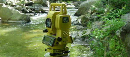
We provide accurate construction stakeout services to guide building and infrastructure development. Our team establishes precise reference points for foundations, utilities, and structures using advanced surveying equipment. This ensures alignment with approved plans and minimizes costly construction errors during project execution.
Hydrologic Surveys
Our hydrologic surveys assess water flow patterns and flood risks for land development projects. We analyze drainage systems and create floodplain maps to inform infrastructure design. This data supports stormwater management solutions and regulatory compliance for developments near water bodies.
People
P. Massie Saunders, Jr.
President
Third-generation leader of Saunders' Surveys with over 30 years of experience in land surveying and engineering. Specializes in historical boundary analysis and complex land dispute resolution. Maintains the company's commitment to preserving surveying heritage while implementing modern technologies.
Questions
What surveying services do you offer?
We provide boundary surveys, topographic mapping, site development, construction stakeout, hydrologic surveys, and specialized projects like cemetery mapping and athletic facility design.
How long have you served Central Virginia?
Saunders' Surveys has provided professional surveying services since 1915, maintaining continuous operations for over a century in Central Virginia.
What areas do you cover?
We serve Nelson, Amherst, Campbell, Buckingham, Albemarle, Augusta, and Rockbridge Counties in Central Virginia, with projects extending to West Virginia.
How do you handle boundary disputes?
We resolve disputes using historical records, original plats, and field notes dating back 100 years, preventing many cases from reaching court through accurate data analysis.
What makes your services unique?
Our combination of historical archives (90% of original plats), 12,000+ completed projects, and preservation of vintage surveying equipment provides unmatched expertise in boundary determination.
Are your surveyors licensed?
Yes, we hold active licenses as Professional Engineers (#22387) and Land Surveyors (#1636) in Virginia, ensuring compliance with all state regulations.