Business Details
17 Years
experience
Your Trusted Surveying & Engineering Partner
Mountain Plains was founded in 2009 with a clear mission: to deliver precision engineering and surveying solutions that transform complex infrastructure challenges into sustainable success. Our team of over 55 professionals combines advanced technology with deep regional expertise to serve clients across the Northern Plains. We specialize in land surveying, civil engineering, line locating, drone services, GIS, and electrical consulting, ensuring comprehensive project support from concept to completion. Our commitment to innovation is matched only by our dedication to core valuesintegrity, safety, quality, family, and accountability. With offices in North Dakota, Montana, and Wyoming, we provide localized knowledge while maintaining national technical standards.Our integrated approach enables faster project completion, reduced costs, and enhanced accuracy through seamless coordination of services. We treat every client's business as our own, delivering solutions that exceed expectations while adhering to strict regulatory compliance. Our state-of-the-art equipmentincluding Trimble GPS systems, LiDAR technology, and aerial dronesensures unmatched precision in every project. With 15 years of continuous growth, we remain focused on our founding promise: energizing regional development through technical excellence and unwavering accountability.
Services
Land Surveying
Civil Engineering
Line Locating
Drone Services
GIS Mapping
Electrical Consulting
Oil Pad Design
Storm Water Management
Utility Locating
3D Mapping
Details
- Year established: 2009
Highlights and features
- We offer 15+ years of specialized expertise in Northern Plains infrastructure projects
- Our team includes 55+ professionals with advanced Trimble and LiDAR technology
- We provide integrated services from survey to final implementation
- Our client-focused approach treats your business like our own
- We maintain strict compliance with local, state, and federal regulations
Services
Land Surveying
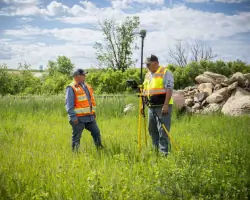
Our land surveying services combine Trimble GPS technology with regional expertise to deliver precise boundary determinations and topographic mapping. We provide ALTA/ACSM surveys, construction staking, and right-of-way documentation for commercial, residential, and energy projects. Our team ensures accurate data collection that supports informed decision-making for infrastructure development.
Civil Engineering
We offer comprehensive civil engineering solutions including site development, roadway design, and utility infrastructure planning. Our engineers create optimized layouts for commercial developments, municipal projects, and energy facilities while ensuring regulatory compliance. We specialize in stormwater management systems and sanitary sewer design that balance functionality with environmental considerations.
Line Locating
Our line locating services use ground-penetrating radar and electromagnetic detection to identify underground utilities with precision. We provide both public and private utility locating for construction projects, pipeline maintenance, and excavation safety. Our team documents findings with GPS mapping to prevent costly damages during infrastructure development.
Drone Services
We deploy FAA-certified drone operators to capture high-resolution aerial imagery and LiDAR data for construction monitoring and land analysis. Our drone services produce detailed 3D models, orthomosaic maps, and volume calculations that enhance project planning. We maintain Blue UAS List approval for operations near sensitive infrastructure.
GIS Services
Our GIS experts create customized mapping solutions that integrate infrastructure data, environmental factors, and demographic information. We develop interactive GIS databases for utility management, land planning, and asset tracking. Our spatial analysis capabilities support decision-making for municipal projects, energy infrastructure, and environmental assessments.
Questions
What services does Mountain Plains offer?
We provide land surveying, civil engineering, line locating, drone services, GIS mapping, and electrical consulting for infrastructure projects across the Northern Plains.
Which states do you serve?
We operate throughout North Dakota, South Dakota, Montana, Wyoming, and Idaho with localized knowledge and regional expertise.
How experienced is your team?
Our 55+ professionals bring 15+ years of combined experience with advanced certifications in surveying, engineering, and drone operations.
What technology do you use?
We utilize Trimble GPS systems, LiDAR scanners, aerial drones, and specialized software for precision data collection and analysis.
How do you ensure project compliance?
Our team maintains strict adherence to local, state, and federal regulations through comprehensive documentation and quality control processes.
Can you handle complex infrastructure projects?
Yes, our integrated approach coordinates surveying, engineering, and implementation to manage complex projects from concept to completion.