Business Details
38 Years
experience
Expert Land Surveying Services in Houston
Since 1988, EIC Surveying has been a trusted provider of comprehensive land surveying services across the Greater Houston area. Our team handles every phase of the surveying process in-house, from initial research and field data collection to final plat creation and delivery. With expertise in title surveys, boundary determinations, construction layout, and elevation certifications, we serve residential, commercial, and municipal clients. Our full-service approach ensures seamless project execution through dedicated phone, email, and web-based communication channels. We specialize in complex projects including subdivision development, floodplain analysis, and utility infrastructure planning.Our licensed professionals maintain up-to-date jurisdictional requirements for Houston-area municipalities to ensure regulatory compliance. By combining decades of local experience with modern surveying technology, we deliver precise, legally defensible results. Our commitment to quality extends to public hearing representation and multi-phase submittal management for platting projects. We maintain strict adherence to professional standards while providing transparent, client-focused service. Our goal is to be recognized as the premier surveying firm through consistent delivery of accurate, timely solutions tailored to each client's specific needs.
Services
Land Surveying
Title Surveys
ALTA Surveys
Boundary Surveys
Construction Layout
Topographic Services
Platting Services
Elevation Certificates
Subdivision Design
Builder's Packages
Details
- Year established: 1988
Highlights and features
- We handle all surveying phases in-house from research to final delivery
- Our team maintains current jurisdictional requirements for Houston-area municipalities
- We offer 34 years of continuous surveying experience in the Greater Houston area
- Our licensed professionals provide public hearing representation for platting projects
- We combine modern technology with strict adherence to professional standards
Services
Land Surveying
Our land surveying services establish precise property boundaries using historical records and modern measurement techniques. We provide legally defensible surveys for real estate transactions, construction projects, and legal disputes. Our team handles all aspects from initial research to final plat creation.
Elevation Certificates
We provide FEMA-compliant elevation certificates for flood insurance requirements and building permits. Our licensed surveyors measure structure elevations relative to flood zones and deliver official documentation with photographic evidence for insurance providers.
Platting Services
Our platting services facilitate legal land division through municipal approval processes. We prepare preliminary and final plats addressing road layouts, utility easements, and drainage requirements while representing clients at public hearings for development projects.
Construction Layout
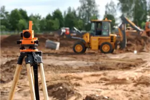
We provide precise construction layout services for buildings, utilities, and infrastructure projects. Our team stakes underground utilities, paving lines, and building corners with elevation measurements to ensure accurate project execution according to approved plans.
Builder's Packages
Our builder's packages include multi-phase survey solutions for residential and commercial developments. The three-phase package covers boundary surveys, form/slab verification, and final as-built surveys to support construction projects from start to completion.
People
Craig A. Laney
Registered Professional Land Surveyor
With extensive experience in Texas land surveying, Craig A. Laney leads survey operations ensuring technical accuracy and regulatory compliance for residential and commercial projects across the Houston area.
Emil Haddad
Registered Professional Land Surveyor
Emil Haddad contributes specialized expertise in elevation certifications and floodplain analysis, managing critical survey components for insurance requirements and municipal development approvals in southeast Texas.
Questions
What is land surveying?
Land surveying establishes property boundaries using historical records and modern measurements. It includes boundary determination, construction layout, and legal description preparation for real estate transactions and development projects.
When is a new survey required?
A new survey is needed when buying/selling property, before construction, for boundary disputes, or when an existing survey is over 10 years old to ensure current legal compliance and liability protection.
What does platting involve?
Platting divides land into legal parcels through municipal approval processes. It addresses road layouts, utility easements, and drainage requirements while requiring public hearings and multiple submittals to local jurisdictions.
Why get an elevation certificate?
Elevation certificates determine flood insurance rates by measuring structure elevations relative to FEMA flood zones. They're required for building permits and insurance in flood-prone areas to establish proper risk assessment.
What services do surveyors provide for builders?
We offer three-phase builder packages including boundary surveys, form/slab verification, and final as-built surveys to support accurate construction execution and municipal compliance for residential and commercial developments.