Business Details
Expert Land Surveying Services in McMinnville, OR
TerraCalc Land Surveying was founded to bridge the technological gap between contractors and GPS- and robotic-guided earthmoving equipment. Our team combines 90 years of collective experience in construction layout, boundary resolution, and topographic mapping with cutting-edge technology like aerial photography and lidar systems. We specialize in precise earthwork modeling, customized excavation calculations, and machine control applications, ensuring clients achieve greater productivity and accuracy. Licensed in Oregon, Washington, and California, our professionals prioritize education, real-world field experience, and adherence to industry standards.We deliver reliable, secure data through advanced software platforms like AGTEK Earthwork 4D and Trimble Business Center. Our commitment to quality is reflected in our experienced field crews, rapid response times, and tailored solutions for construction, sitework estimating, and terrain modeling. By maintaining the latest survey instruments and software, we empower clients to meet project demands efficiently while upholding the highest standards of professionalism and confidentiality.

Services
Land Surveying
Sitework Estimates
Terrain Modeling
Survey Equipment
Highlights and features
- We offer 90 years of combined experience in construction layout and boundary resolution.
- Our team uses advanced aerial photography and lidar mapping systems for precision.
- Licensed professionals in Oregon, Washington, and California ensure compliance and expertise.
- We provide rapid response times and customized earthwork modeling for construction needs.
- Our equipment includes Trimble S7 Robotic Total Stations and AGTEK Earthwork 4D software.
Services
Land Surveying
TerraCalc provides traditional and technologically advanced land surveying services, including boundary resolution, construction layout, and FEMA flood certifications. Our crews use GPS and robotic equipment for real-time data collection, ensuring accuracy in boundary mapping and site development. This service supports clients in resolving property disputes and planning infrastructure projects with reliable measurements.
Sitework Estimates
We deliver precise sitework estimates for underground utilities, concrete flatwork, and site improvements using AGTEK Earthwork 4D and Autodesk Civil 3D software. Our team quantifies materials needed for construction phases, helping clients budget accurately. This service reduces cost overruns by providing detailed calculations for retaining walls, paving, and landscaping projects.
Terrain Models
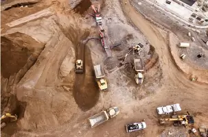
Our terrain modeling service creates customized 3D digital elevation models for construction and machine control applications. Using lidar and Trimble Business Center software, we generate accurate topographic data for grading and excavation planning. This technology enhances productivity by enabling contractors to visualize site conditions and optimize earthmoving operations.
Survey Equipment
TerraCalc maintains advanced survey equipment, including Trimble R12i GPS receivers, S7 Robotic Total Stations, and DINI digital levels. Our tools integrate with software platforms like TopCon 3D Office to support real-time data sharing between field and office teams. This ensures clients receive up-to-date measurements and seamless project coordination for complex developments.
People
K. Jay Pannell
President
With 30 years of surveying experience, K. Jay Pannell leads TerraCalc's operations, specializing in digital terrain modeling and machine control support for GPS-guided equipment.
H. Gordy Stedman
Project Surveyor
Licensed in Oregon, H. Gordy Stedman brings 30 years of expertise in boundary surveys and Trimble GCS machine control systems to TerraCalc's projects.
Darren Harr
Project Surveyor
Darren Harr, licensed in four states, specializes in ALTA surveys, subdivisions, and topographic mapping with 30 years of professional experience.
Craig Newton
Project Surveyor
Craig Newton contributes 16 years of boundary survey expertise and a computer science background to TerraCalc's advanced surveying solutions.
Dustin Huntley
Crew Chief
Dustin Huntley oversees field operations with 14 years of experience in construction staking, oil field surveys, and topographic mapping.
Questions
What services does TerraCalc Land Surveying offer?
We specialize in land surveying, terrain modeling, sitework estimates, and machine control applications using GPS and robotic technology.
Are your surveyors licensed?
Yes, our professionals are licensed in Oregon, Washington, and California with decades of field experience.
What technology do you use for surveys?
We use Trimble S7 Robotic Total Stations, AGTEK Earthwork 4D software, and lidar mapping systems for precision.
Do you provide earthwork modeling for construction?
Yes, we create customized 3D terrain models for accurate excavation calculations and machine control applications.
What industries do you serve?
We support commercial, residential, infrastructure, and industrial projects including schools, airports, and healthcare facilities.