Business Details
22 Years
experience
Professional Land Surveying Services in Alamosa, CO
Russell Surveyors & Associates has been delivering professional land surveying services since 2004, serving Southern Colorado and Northern New Mexico. Our team combines over 50 years of collective experience with state licensing and insurance to ensure precision and reliability. We specialize in construction staking, elevation certification, boundary surveys, and municipal survey services, utilizing legal parameters and advanced technology to meet client needs. As members of the Professional Land Surveyors of Colorado and the Colorado Association of County Surveyors, we uphold industry standards and local expertise. Our principal, Daniel M. Russell, brings 33 years of regional experience, including specialized work in mining claim retracement and subdivision design.We prioritize client collaboration, offering appointments outside standard hours to accommodate project demands. Our commitment to continuous education and adherence to statutory law ensures accurate, legally sound results. Licensed in Colorado, Arizona, and New Mexico, we serve residential and commercial clients with tailored solutions. Our reputation for quality work and community-focused service has made us a trusted partner in the San Luis Valley region. We maintain transparency in operations and guarantee insured, code-compliant deliverables for every project.

Services
Land Surveying
Construction Staking
Elevation Certification
Boundary Surveys
Municipal Survey Services
Details
- Year established: 2004
Highlights and features
- We have over 50 years of combined experience in land surveying
- Our team includes licensed professionals in three states
- We specialize in complex mining claim retracement projects
- Our services comply with Colorado Real Property Boundary Law
- We offer flexible appointment scheduling including evenings
Associations and certifications
- Professional Land Surveyors of Colorado
- Colorado Association of County Surveyors
Services
Land Surveying
Our comprehensive land surveying services cover boundary determination, topographic mapping, and legal documentation. We use GPS control surveys and aerial mapping technology to deliver precise measurements for residential and commercial properties. Our team's expertise in Colorado Real Property Boundary Law ensures legally defensible results that meet municipal requirements.
Construction Staking
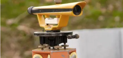
We provide accurate construction staking services for infrastructure and building projects. Our process establishes precise reference points using digital terrain models and total station instruments. This ensures proper alignment and elevation for foundations, roads, and utilities, minimizing costly rework during construction phases.
Elevation Certification
Our elevation certifications determine property flood risk zones through detailed elevation measurements. We create FEMA-compliant documentation for insurance requirements and building permits, using differential leveling techniques to verify structure elevations relative to base flood elevations.
Boundary Surveys
We conduct thorough boundary surveys to resolve property disputes and establish legal land divisions. Our process includes title document research, physical evidence analysis, and monumentation of corners. We follow the Colorado Supreme Court's boundary law precedents to deliver court-admissible survey results.
Municipal Surveys
We support local governments with municipal survey services including right-of-way mapping and infrastructure planning. Our team performs ALTA/ACSM surveys for public projects and prepares subdivision plats that meet county recording standards, ensuring compliance with local zoning regulations.
People
Daniel M. Russell
Principal / President
With 33 years of regional experience, Daniel leads survey operations and project management. He holds professional licenses in Colorado, Arizona, and New Mexico, and contributed to Colorado boundary law research. His expertise spans mining claim retracement and GPS control surveys.
Anthony Martin
Land Surveyor
Licensed in Colorado since 2012, Tony specializes in construction staking and mining surveys. He has 12 years of field experience and completed advanced coursework in railroad surveying and Colorado easement law. Certified as a Federal Surveyor since 2016.
Questions
What areas do you serve?
We serve Southern Colorado and Northern New Mexico, focusing on the San Luis Valley region and surrounding communities.
Are your surveyors licensed?
Yes, our team includes licensed professionals in Colorado, Arizona, and New Mexico with specialized certifications in federal surveying.
What survey types do you offer?
We provide boundary surveys, construction staking, elevation certifications, ALTA/ACSM surveys, and mining claim retracement services.
How long have you been in business?
We've operated continuously since 2004, with our principal surveyor having over 30 years of regional experience.
Can you handle commercial projects?
Yes, we serve both residential and commercial clients with solutions tailored to project scale and complexity requirements.
Do you offer emergency services?
We don't provide emergency services but offer flexible scheduling with appointments available outside standard business hours.