Business Details
7 Years
experience
Premier Hydrographic Surveying Services
Seaworks Group is a premier full-service marine consulting firm specializing in hydrographic surveying and underwater mapping. Our team of NSPS/THSOA-certified hydrographers brings decades of combined experience in delivering precise bathymetric data for complex marine environments. We leverage cutting-edge technology including multibeam sonar, mobile LiDAR, and advanced ROV systems to serve clients across the Midwest and Northeast regions. Our exclusive focus on hydrography ensures unmatched expertise in subsurface inspections, geophysical investigations, and coastal infrastructure assessments.Headquartered in Michigan with a satellite office in New Jersey, we maintain strategic proximity to major waterways including the Great Lakes and Mississippi River systems. Our HUBZone certification underscores our commitment to providing high-quality services while supporting economic development in underserved areas. With thousands of completed surveys and partnerships with leading engineering firms, we deliver reliable data solutions for dam inspections, pipeline assessments, and environmental monitoring projects nationwide.
Services
Hydrographic Surveying
Underwater Inspection
Geophysical Investigation
Mobile LiDAR Scanning
ROV Inspections
Vibracore Sampling
Sub-bottom Profiling
Details
- Year established: 2019
Highlights and features
- We specialize exclusively in hydrography, ensuring unmatched expertise.
- Our team includes NSPS/THSOA-certified professionals with thousands of surveys completed.
- We utilize cutting-edge sonar and LiDAR technology for precise data collection.
- Our service area covers the Midwest and Northeast, including all Great Lakes and river systems.
- We are HUBZone Certified, demonstrating our commitment to excellence.
Associations and certifications
- NSPS/THSOA Certified Hydrographer
- HUBZone Certified Small Business
Services
Hydrographic Surveying
Our hydrographic surveying service creates detailed underwater maps using dual-frequency sonar and multibeam systems. We provide precise depth measurements and seabed characterization for navigation channels, port facilities, and environmental monitoring. Our NSPS-certified hydrographers ensure data accuracy meets federal standards for infrastructure projects.
Underwater Inspection
We perform underwater structure inspections using ROVs and high-resolution sonar imaging. Our technology detects structural defects in dams, bridge foundations, and utility crossings without requiring dewatering. Clients receive comprehensive reports with 3D modeling of submerged infrastructure conditions.
Geophysical Investigation
Our geophysical services combine magnetometer surveys, vibracore sampling, and sub-bottom profiling. This multi-method approach identifies buried objects, sediment layers, and geological features for pipeline routing and environmental assessments. Data supports engineering decisions for coastal protection and dredging projects.
Mobile LiDAR Scanning
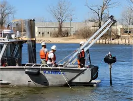
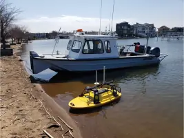
We deploy mobile LiDAR systems to create high-resolution topographic and bathymetric point clouds. Our amphibious survey vessels capture above-and-below-water data simultaneously, reducing project timelines by 40% compared to traditional land survey crews while maintaining 2cm accuracy.
ROV Inspections
Our high-definition ROV systems perform detailed underwater inspections in challenging environments. Equipped with 4K cameras and sonar, these remotely operated vehicles provide real-time video feeds for assessing submerged structures, pipelines, and environmental habitats with minimal disruption.
Questions
What geographic areas do you serve?
We operate throughout the Midwest and Northeast, covering all Great Lakes, Mississippi River tributaries, and coastal Northeast waters from Michigan to New Jersey.
Are your hydrographers certified?
Yes, our lead hydrographer holds NSPS/THSOA certification, the highest professional accreditation in the hydrographic surveying industry.
What technologies do you use?
We employ multibeam sonar, mobile LiDAR, ROVs, sub-bottom profilers, and magnetometers for comprehensive underwater data collection.
Can you handle emergency inspections?
While we don't offer 24/7 emergency services, we prioritize urgent requests and typically mobilize within 24-48 hours for critical infrastructure assessments.
What industries do you work with?
We serve engineering firms, government agencies, energy companies, and construction contractors requiring precise marine data for infrastructure projects.