Business Details
41 Years
experience
Professional Land Surveying & Engineering Services in Bar Harbor, ME
Established in 1985, Nichols Paul F Civil Engineer & Land Surveyor has provided professional land surveying and civil engineering services across Maine, New Hampshire, and Massachusetts for over 30 years. Our expertise spans boundary surveys, topographic mapping, wetland permitting, and land planning, supported by advanced GPS technology and adherence to evolving industry standards. With licenses as a Professional Engineer (PE), Professional Land Surveyor (PLS), and Land Surveyor (LLS), we combine technical precision with deep regional knowledge to serve public and private sector clients.Our work includes conservation easements, coastal permitting, and infrastructure design, reflecting a commitment to accuracy and client collaboration. Backed by memberships in the Maine Society of Land Surveyors and New Hampshire Land Surveyors Association, we prioritize ethical practices and continuous education in boundary law and technological innovations. Clients benefit from personalized service, free initial consultations, and a proven track record in resolving complex land use challenges.
Services
Boundary Surveys
Topographic Surveys
ALTA/ACSM Surveys
Wetland Permitting
Land Planning
Coastal Design
Subdivision Surveys
Flood Zone Certificates
Septic Design
Site Plans
Details
- Year established: 1985
Highlights and features
- 30+ years of experience in land surveying and civil engineering
- Licensed in Maine, New Hampshire, and Massachusetts
- Free initial consultation for property survey needs
- Utilizes advanced GPS technology for accurate measurements
- Active member of Maine Society of Land Surveyors and NH Land Surveyors Association
Services
Boundary Surveys
Our boundary surveys precisely determine property lines through comprehensive deed research, field measurements, and corner marking. This service resolves disputes, supports real estate transactions, and ensures regulatory compliance. Clients receive detailed plans and documentation for both residential and commercial properties.
ALTA/ACSM Surveys
We conduct ALTA/ACSM land title surveys to meet strict insurance requirements for commercial properties. These detailed assessments identify easements, encroachments, and boundary improvements, providing critical data for property transactions and development projects.
Wetland Permitting
Our team navigates wetland permitting processes for inland and coastal areas, ensuring projects comply with environmental regulations. We handle submissions to agencies like the Army Corps of Engineers and coordinate mitigation strategies for development projects.
Topographic Surveys
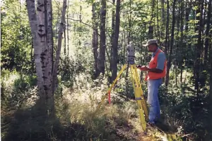
Topographic surveys capture natural and man-made features with elevation data, supporting site planning and construction. Using advanced GPS technology, we create accurate 3D models for engineering design and land development purposes.
Land Planning
We provide integrated land planning services including subdivision design, utility layout, and zoning compliance. Our solutions balance client needs with environmental considerations, optimizing land use for residential, commercial, and municipal projects.
People
Nichols Paul F Civil Engineer & Land Surveyor
Professional Engineer & Land Surveyor
Licensed PE and PLS with 30+ years of experience in land surveying and civil engineering. Specializes in boundary disputes, coastal permitting, and land planning across three states. Holds degrees from UMass Lowell and NH Technical Institute.
Questions
What services do you offer?
We provide boundary surveys, topographic mapping, wetland permitting, ALTA/ACSM surveys, land planning, and coastal design services for residential, commercial, and municipal clients.
Which areas do you serve?
Our primary service areas include Maine, New Hampshire, and Massachusetts, with extensive experience in coastal and inland land surveying projects.
How long have you been in business?
Paul F. Nichols has provided land surveying and engineering services since 1985, with over 30 years of professional experience in the field.
What is your consultation process?
We offer free initial consultations to discuss property needs, followed by site inspections and detailed proposals outlining scope, costs, and timelines within 48 hours.
Do you handle permit applications?
Yes, we assist with wetland permits, coastal construction permits, and other regulatory submissions through local, state, and federal agencies including the Army Corps of Engineers.
What technology do you use?
We utilize advanced GPS technology and digital mapping systems to ensure precise measurements and efficient data collection for all surveying and engineering projects.