Business Details
Your Trusted Partner for Land Surveying & Environmental Services in Perham, MN
Compass Consultants has been dedicated to meeting client needs with speed, accuracy, and attention to detail for over 65 years. Our expertise spans land surveying, environmental planning, infrastructure services, and project management, serving commercial and residential clients across Minnesota, North Dakota, and South Dakota. We invest continuously in staff training, certifications, and advanced technology to ensure reliable, high-quality results. Our team of Registered Land Surveyors and professionals excels in property boundary delineation, regulatory compliance, and environmental impact assessments.We pride ourselves on client-centric solutions, including NESC compliance audits, flood zone determinations, and GIS mapping. With a legacy of trust and precision, we guide clients through complex projects while maintaining strict adherence to federal, state, and local regulations. Our commitment to excellence is reflected in testimonials highlighting problem-solving capabilities, cost savings, and timely project delivery.


Services
Land Surveying
Environmental Services
Infrastructure Services
Project Management
Property Line Surveys
NESC Compliance Audits
Flood Zone Determination
Regulatory Permitting
GIS Mapping
Construction Surveys
Highlights and features
- We offer 65+ years of combined experience in land surveying and environmental consulting.
- Our team includes Registered Land Surveyors with advanced certifications and training.
- We utilize cutting-edge GPS and GIS technology for precise property boundary assessments.
- We provide comprehensive regulatory compliance solutions for complex permitting requirements.
- Our client testimonials highlight problem-solving excellence and cost-saving efficiency.
What people say
Excellent engineering services
Helped us get LOMA approved
Went above and beyond
Saved us money
Professional and efficient
Services
Land Surveying
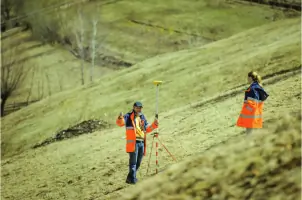
Our land surveying services provide precise property boundary assessments using advanced GPS technology and traditional surveying tools. We specialize in residential and commercial projects, ensuring accurate delineation of property lines, easements, and encroachments. With Registered Land Surveyors and experienced field crews, we deliver reliable data for legal documentation, construction planning, and dispute resolution across Minnesota, North Dakota, and South Dakota.
Environmental Services
We offer comprehensive environmental planning services to identify regulatory requirements and potential impacts for development projects. Our team navigates complex federal, state, and local permitting processes, conducts environmental assessments, and ensures compliance with safety standards. These services help clients avoid legal issues, reduce project delays, and maintain environmental stewardship throughout all project phases.
Infrastructure Services
Our infrastructure services include project management, broadband engineering, and feasibility studies for utility and communication networks. We perform NESC compliance audits, construction inspections, and GIS mapping to ensure infrastructure projects meet safety codes and operational requirements. These solutions help clients implement cost-effective, future-ready infrastructure systems while maintaining regulatory compliance.
Project Management
We provide end-to-end project management for engineering and surveying initiatives, from initial planning to final implementation. Our certified project managers define objectives, allocate resources, and monitor budgets to ensure timely delivery. This service integrates with land surveying and environmental compliance work, offering clients a unified approach to complex development projects across multiple states.
Property Line Surveys
Our property line surveys determine precise land boundaries using modern GPS equipment and historical records. This service resolves neighbor disputes, supports real estate transactions, and guides construction projects. We work closely with attorneys and county offices to ensure legal accuracy, providing documentation that meets municipal requirements and protects property owners' interests.
Questions
What does a land surveyor do?
Land surveyors measure and map property boundaries using GPS technology, surveyor's chains, and specialized tools. They conduct environmental assessments, construction surveys, and provide legal documentation for property transactions.
Why should I get a property survey?
A property survey prevents boundary disputes, identifies easements, and ensures compliance with zoning regulations. It's essential for real estate transactions, construction projects, and resolving neighbor disputes.
How do I read a property survey?
Focus on the scale, datum point, north arrow, property lines, and easements. Solid lines show boundaries, while dashed lines indicate easements. Consult a professional for accurate interpretation.
Can you help with flood zone determinations?
Yes, we assist with FEMA LOMA applications to challenge flood zone designations. Our team secured approval for a client in 30 days, reducing annual flood insurance costs from $4,000 to zero.
Do you provide services outside Minnesota?
We serve Minnesota, North Dakota, and South Dakota for land surveying, environmental services, and infrastructure projects, with expertise in regional regulatory requirements.
What certifications do your surveyors hold?
Our team includes Registered Land Surveyors with ongoing training in the latest technologies and compliance standards for accurate, legally defensible survey results.