Business Details
50+ Years
experience
Expert Land Surveying Services in Detroit Lakes, MN
Meadowland Surveying has been dedicated to precision and reliability in land surveying since 1946. Our history of excellence began with founder Carl J. Nedberg, whose commitment to accurate service established a foundation of trust. Over decades, successive owners Donald D. Busker and Roy A. Smith upheld these standards, with Scott R. Walz continuing this legacy since 2001. We specialize in boundary surveys, topographic mapping, and construction staking, serving attorneys, architects, engineers, and government agencies. With over 15,000 completed surveys, our team combines technical expertise with clear communication to meet client needs.We maintain strong relationships with local professionals and prioritize timely, cost-effective solutions. Our work supports residential, commercial, and infrastructure projects across Becker County and surrounding areas. By blending traditional values with modern technology, we ensure accurate results for every project. Clients consistently praise our professionalism, responsiveness, and ability to explain complex survey details clearly. As a family-owned business, we remain committed to the same principles that have defined us for over 75 years.
Services
ALTA/NSPS Surveys
Property Subdivision
Topographic Surveys
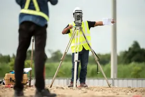
Construction Staking
Impervious Surface Surveys
Boundary Surveys
Property Splits
Details
- Year established: 1946
Highlights and features
- We have over 75 years of continuous experience in professional land surveying.
- Our team has completed more than 15,000 surveys in the lakes area.
- We maintain strong working relationships with legal and government professionals.
- We provide clear explanations of complex survey details for client understanding.
- Our family-owned business combines traditional values with modern technology.
What people say
Professional and accurate
Timely service
Excellent results
Highly recommend
Knowledgeable staff
Services
ALTA/NSPS Surveys
ALTA/NSPS Surveys provide comprehensive commercial property assessments meeting title insurance requirements. Our team creates detailed maps showing boundary lines, structures, easements, and other critical features. This service supports major real estate transactions and development projects.
Property Subdivision
Property Subdivision services create legal lots for residential or commercial development. We handle survey work, public hearings, and documentation for planned unit developments and common interest communities. Our process ensures compliance with local zoning regulations.
Topographic Surveys
Topographic Surveys map existing site conditions including elevations, structures, and water features. These surveys support construction planning and permit applications. We include boundary markers, impervious surfaces, and utility locations in our detailed documentation.
Construction Staking
Construction Staking establishes precise building locations for new developments. Our team marks critical points for foundations, roads, and infrastructure projects. This service ensures accurate implementation of architectural and engineering plans during construction phases.
Boundary Surveys
Boundary Surveys establish legal property lines through physical monumentation. We identify encroachments and create scaled maps showing boundary corners. This service includes legal description drafting for property transfers and dispute resolution.
People
Scott R. Walz
President
Scott R. Walz oversees all survey operations with 20+ years of leadership experience. He maintains the company's founding principles of accuracy and professionalism while integrating modern surveying technologies for improved efficiency and client service.
Carl J. Nedberg
Founder
Carl J. Nedberg established Meadowland Surveying in 1946 with a commitment to precise, dependable service. His foundational work created the reputation for excellence that continues through subsequent generations of surveying professionals at the company.
Roy A. Smith
Former Owner
Roy A. Smith led the company from 1981 to 2001, building on Nedberg's legacy. Known for his approachable expertise, he specialized in explaining complex survey matters clearly to clients while maintaining strict technical standards.
Donald D. Busker
Former Owner
Donald D. Busker owned the company from 1969 to 1981, continuing Nedberg's tradition of excellence. He expanded the firm's capabilities while maintaining its focus on accurate, reliable surveying services for local clients.
Tiffiny
Professional Surveyor
Tiffiny provides expert surveying services with specialized knowledge of local land records and boundary determination. She works closely with clients to ensure clear understanding of survey results and documentation.
Questions
What types of surveying services do you offer?
We provide ALTA/NSPS surveys, property subdivisions, topographic mapping, construction staking, boundary surveys, and impervious surface assessments.
How can I request a survey?
Contact us through our website form or call 218.847.4289 to discuss your project requirements with our staff.
How long have you been in business?
We've provided surveying services since 1946, with over 75 years of continuous operation in Detroit Lakes.
Which areas do you serve?
We primarily serve Becker County and surrounding areas including Detroit Lakes and Ottertail County.
Can you work with real estate transactions?
Yes, we frequently collaborate with real estate professionals on property surveys and boundary determinations.
Do you handle government projects?
Yes, we've completed multiple township road surveys and work with various local government agencies.