
Business Details
Your Trusted Partner for Land Surveying Services in Cave Creek
Everett Alan Group has been delivering high-quality land surveying and engineering services for over 30 years. Our team of experienced professionals, led by Registered Land Surveyor James Alan Loftis, specializes in residential and commercial projects across Maricopa County. We utilize advanced technology, including drone surveying, to ensure precision and efficiency. Our commitment to integrity, client satisfaction, and hands-on project management has established us as a trusted partner in the industry.We handle everything from boundary surveys and elevation certificates to complex engineering solutions, tailoring our services to meet each client's unique needs. With decades of local expertise and a focus on innovation, we provide reliable, timely results that exceed expectations.


Services
Land Surveying
Boundary Surveys
Elevation Certificates
Topographic Surveys
Construction Staking
ALTA Surveys
Engineering Services
Septic System Design
Drone Surveying
Lot Splits
Highlights and features
- We offer over 30 years of hands-on experience in Arizona land surveying.
- Our team provides comprehensive services from boundary surveys to drone mapping.
- We prioritize client satisfaction with personalized, transparent communication.
- Our owner-led approach ensures consistent quality and accountability.
- We utilize cutting-edge technology for accurate, efficient results.
What people say
Accurate and reliable results
Excellent service
Top notch professionals
Impeccable work
Highly recommend
Services
Land Surveying
Everett Alan Group provides comprehensive land surveying services for residential and commercial properties. Our surveys establish precise boundaries, easements, and topographic features. With over 30 years of experience and advanced tools like drone technology, we ensure accurate data collection and mapping to support construction, sales, or development projects.
Elevation Certificates
We specialize in elevation certificates for flood insurance requirements. Our surveys determine property elevations relative to flood zones, helping clients assess risk and compliance. This service is critical for disputing flood zone designations or securing accurate insurance rates for properties in Maricopa County.
Topographic Surveys
Our topographic surveys capture detailed 3D data on land features, including contours, vegetation, and structures. Using drone technology, we create precise maps for engineering, construction, and real estate purposes. These surveys support site planning, grading, and drainage analysis for residential and commercial developments.
Construction Staking
We provide construction staking services to mark building locations, roads, and utilities for new developments. Our team ensures accurate horizontal and vertical placement of structures, guiding contractors through complex projects. This service guarantees compliance with site plans and local regulations for seamless construction processes.
Drone Surveying
Everett Alan Group uses drones for efficient, high-resolution property surveys. This technology captures detailed 3D topographical maps, ideal for large sites or complex terrain. Clients receive digital files for precise planning, enabling accurate quotes and streamlined workflows for construction or real estate projects.
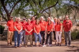
People
James Alan Loftis
Owner, Registered Land Surveyor
Licensed since 1992, James brings over 30 years of Arizona surveying expertise. He oversees all projects personally, ensuring accuracy and client satisfaction through hands-on leadership and technical excellence.
Steve Taranowski
Registered Land Surveyor, Licensed Drone Pilot
Steve combines traditional surveying skills with advanced drone technology to deliver precise, efficient mapping solutions for complex projects across Maricopa County.
George Everland
Civil Engineer
George provides expert engineering support for grading, drainage, and site development projects, ensuring technical compliance and practical solutions for residential and commercial clients.
Lisa Loftis
Business Manager
Lisa manages operations and client communications, ensuring smooth project coordination and timely delivery of services while maintaining high standards of professionalism.
Amber Casper
Office Manager
Amber oversees administrative operations, supporting field teams and clients with organizational expertise to maintain efficient workflows and exceptional service quality.
Questions
What services does Everett Alan Group offer?
We provide land surveying, elevation certificates, topographic mapping, construction staking, engineering solutions, and drone surveys for residential and commercial clients in Maricopa County.
How long has Everett Alan Group been in business?
Our team has over 30 years of combined experience, with owner James Alan Loftis licensed since 1992, serving Cave Creek and surrounding areas.
Do you serve areas outside Cave Creek?
Yes, we work throughout Maricopa County, including Scottsdale, Phoenix, Carefree, and Rio Verde, providing consistent quality across all locations.
What makes your surveys accurate?
We use advanced tools like drones and GPS technology, combined with decades of expertise, to ensure precise measurements and reliable data collection.
Can you help with permit violations?
Yes, we assist homeowners in evaluating and resolving Maricopa County permit violations through accurate surveys and guidance on corrective actions.
How do I request a quote?
Contact us at (480) 990-0545 or via our website form to discuss your project details and receive a customized quote for services.