Business Details
33 Years
experience
Your Trusted Land Surveyors in Lawndale, NC
Established in 1993, Lattimore and Peeler have built a reputation as trusted land surveyors serving Charlotte and surrounding regions. With over 50 years of combined experience, our team specializes in boundary surveys, topographic mapping, and construction staking while maintaining CFS certification for floodplain assessments. We prioritize precision and affordability, offering tailored solutions for residential and commercial clients across North and South Carolina.Our commitment to quality is reflected in our long-standing membership with the North Carolina Society of Surveyors and National Society of Professional Surveyors. Led by licensed professionals Dobbin Lattimore and Don Peeler, we combine technical expertise with personalized service to meet diverse surveying needs. Our local knowledge and dedication to client satisfaction have made us a preferred choice for accurate land assessments since the early 1990s.


Services
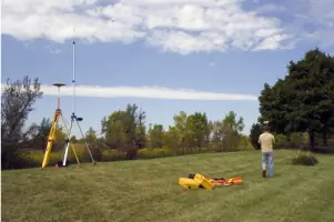
Land Surveying
Topographic Survey
Construction Survey
Mortgage Survey
Site Plan Design
Boundary Retracement
GPS Mapping
Floodplain Survey
Subdivision Layout
Elevation Certificates
Details
- Year established: 1993
Highlights and features
- We offer 50+ years of combined surveying experience in North and South Carolina
- Our team holds Certified Flood Plain Surveyor (CFS) designation for floodplain assessments
- We provide tailored solutions for both small residential and large commercial projects
- Our local expertise covers Charlotte, Gastonia, Asheville, and Spartanburg areas
- We maintain active memberships with North Carolina Society of Surveyors and NSPS
Associations and certifications
- Certified Flood Plain Surveyor (CFS)
Services
Land Surveying
Our comprehensive land surveying services cover boundary determination, property line verification, and legal documentation. With advanced GPS technology and 50+ years combined experience, we deliver precise measurements for residential and commercial properties across North and South Carolina. Our CFS-certified team ensures compliance with all state and federal regulations.
Topographic Survey
We create detailed topographic maps showing natural and man-made features for construction planning and land development. Using modern surveying equipment, our team accurately documents elevation changes, vegetation, and structures to support engineering and architectural projects throughout the Carolinas.
Construction Survey
Our construction survey services include site layout, foundation staking, and elevation control for residential and commercial developments. We work closely with contractors to ensure accurate implementation of building plans, maintaining strict quality standards throughout the construction process in Charlotte and surrounding areas.
Floodplain Survey
As Certified Flood Plain Surveyors, we provide detailed flood risk assessments and elevation certificates. Our specialized services help property owners and developers understand flood zone requirements and secure appropriate insurance coverage across North and South Carolina.
Site Plan Design
We create comprehensive site plans integrating survey data with development requirements. Our plans include building placements, utility layouts, and drainage solutions that comply with local zoning regulations, supporting successful permitting and construction projects in Lawndale and surrounding regions.
People
Dobbin Lattimore
Licensed Professional Land Surveyor
Licensed since 1991, Dobbin holds a Bachelors in Engineering from NC State University. With over 30 years experience, he specializes in boundary surveys and floodplain assessments while maintaining active roles in local planning boards.
Don Peeler
Licensed Professional Land Surveyor
Licensed since 1992, Don brings expertise in construction surveying and site development. With formal training in civil engineering and community involvement as a volunteer fireman, he contributes technical precision to complex surveying projects.
Questions
What types of land surveying services do you offer?
We provide boundary surveys, topographic mapping, construction staking, floodplain assessments, and site plan development for residential and commercial clients across North and South Carolina.
Are you certified for floodplain surveying?
Yes, our team includes Certified Flood Plain Surveyors (CFS) qualified to perform detailed flood risk assessments and elevation certifications required for insurance and regulatory compliance.
How long have you been in business?
Lattimore and Peeler has provided land surveying services since 1993, with our founding surveyors maintaining professional licenses since the early 1990s.
What areas do you serve?
We primarily serve Charlotte, Gastonia, Asheville, and Morganton in North Carolina, plus Spartanburg, SC. We also accept projects throughout both Carolinas and beyond when needed.
Can you handle both residential and commercial projects?
Yes, our experience covers small residential surveys to large-scale commercial developments, including specialized services for construction projects and property subdivisions.
How do you ensure survey accuracy?
We use advanced GPS technology and follow strict quality control procedures. Our surveyors maintain professional certifications and adhere to state and national surveying standards.