Business Details
37 Years
experience
Professional Land Surveying Services in New York
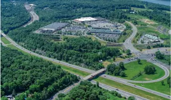
Terry Bergendorff Collins has been a leader in land surveying since 1989, delivering quality services while proactively addressing project challenges. Our team of highly skilled professionals specializes in topographical mapping, boundary surveys, and construction layout, serving clients across New York State with precision and expertise. With over 40 years of combined experience, we prioritize risk prevention, technical quality control, and client satisfaction through formalized procedures and cross-checked technical work. Certified as a Disadvantaged Business Enterprise (DBE) and Women-Owned Business Enterprise (WBE), we support supplier diversity initiatives while maintaining a reputation for meeting tight deadlines and budget constraints. Our services span complex construction projects, properties with underground water easements, and state-funded initiatives, ensuring compliance with regulatory requirements and client expectations.We utilize advanced technologies like LiDAR, drone mapping, and GPS systems to deliver accurate geospatial data. Our commitment to excellence is reflected in our extensive project portfolio, including notable work at The Highlands Shopping Center, where we provided boundary and construction surveys. Headquartered in Brewster, NY, we serve Long Island, New York City, and surrounding counties, offering tailored solutions for engineering and architectural disciplines. Our certifications and technical rigor position us as a trusted partner for clients requiring precise land measurement and mapping services.


Services
Topographical Surveying
Boundary Surveys
Construction Layout
FEMA Flood Certifications
Drone Mapping
ALTA/NSPS Surveys
As-Built Surveys
Wetland Location
GPS Surveying
Land Subdivision
Details
- Year established: 1989
Highlights and features
- We offer 40+ years of combined experience in land surveying and mapping
- Our team adheres to formalized technical quality control procedures
- Certified DBE/WBE status supports supplier diversity initiatives
- We specialize in complex projects requiring multi-level regulatory approvals
- We serve 8+ New York counties with localized expertise
Associations and certifications
- New York State Department of Transportation
- New York State Office of Equal Opportunity
- New York City Small Business Services, Division of Economic and Financial Opportunity
Services
Topographical Surveying
We conduct detailed topographical surveys to create accurate elevation models and terrain maps. Our services support engineering designs and construction planning by identifying natural and man-made features. Using advanced GPS and LiDAR technology, we deliver precise data for site development projects across New York State.
Boundary Surveys
Our boundary surveys establish legal property lines through historical research and field measurements. We locate existing monuments and set new markers to resolve disputes or support real estate transactions. Clients receive official documentation meeting New York State regulatory standards for land ownership verification.
Construction Layout
We provide precise construction layout services for commercial developments, including drainage systems, building footprints, and utility installations. Our team works with contractors to translate design plans into physical markers, ensuring compliance with municipal codes and project specifications throughout New York's diverse terrain.
Drone Mapping
Our drone/UAS mapping services capture high-resolution aerial imagery for large-scale land assessments. We create georeferenced orthomosaics and 3D models that support infrastructure planning and environmental monitoring. This technology enables efficient data collection for complex projects in challenging terrains across our service areas.
ALTA/NSPS Surveys
We perform ALTA/NSPS standard detail surveys for commercial property transactions, meeting insurance and lending requirements. Our comprehensive reports include boundary details, easements, and improvements, ensuring clients have accurate land records for legal and financial decisions in New York's real estate market.
Questions
What geographic areas do you serve?
We provide land surveying services across New York State, including Long Island, New York City, and the Hudson Valley region.
What certifications does your company hold?
We are certified as a Disadvantaged Business Enterprise (DBE) by NYSDOT and as a Women-Owned Business Enterprise (WBE) by New York State and NYC agencies.
What types of surveying technology do you use?
Our equipment includes LiDAR scanning, drone/UAS mapping, GPS systems, and photogrammetric control technologies for precise data collection.
Can you handle complex construction projects?
Yes, we specialize in multi-phase construction surveys requiring regulatory approvals, including drainage, sewer, and building stakeout services.
Do you provide FEMA flood certification services?
Yes, we offer FEMA flood zone determinations and elevation certificates for property development and insurance requirements.