Business Details
36 Years
experience
Trusted Land Surveying Services in Portsmouth, NH
Founded in 1990, James Verra & Associates has been delivering professional land surveying services to residential, commercial, industrial, and municipal clients across New Hampshire and Maine. Our expertise is rooted in over three decades of hands-on experience and access to historical survey records dating back to 1888, including the archives of John W. Durgin and Edward M. Smith. We specialize in boundary surveys, ALTA/NSPS land title surveys, subdivision planning, and utility site surveys, utilizing advanced technologies like GPS and UAV drones to ensure precision.Our team of licensed surveyors combines technical proficiency with deep regional knowledge to resolve complex land-related challenges. We maintain membership in professional organizations to uphold industry standards and provide tailored solutions for property rights, development projects, and legal disputes. Our commitment to accuracy and client satisfaction has solidified our reputation as trusted stewards of the region's surveying history.
Services
ALTA/NSPS Surveys
Boundary Surveys
Subdivision Planning
UAV Drone Surveys
FEMA Elevation Certificates
Utility Site Surveys
Right-of-Way Mapping
Expert Witness Testimony
GPS Surveying
Mineral Pile Volume Surveys
Details
- Year established: 1990
Highlights and features
- We offer 30+ years of experience in New England land surveying since 1990
- Our historical archives include records dating back to 1888 for accurate research
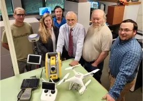
- We utilize advanced GPS and UAV drone technology for precise measurements
- Our team includes licensed surveyors with regional expertise in NH and ME
- We provide comprehensive solutions from boundary surveys to legal testimony
Services
ALTA/NSPS Land Title Surveys
Our ALTA/NSPS land title surveys provide comprehensive property analysis for commercial real estate transactions. We research historical records, delineate boundary lines, identify encroachments, and review zoning ordinances to protect all parties' interests. This service delivers detailed plans that meet national standards while addressing specific legal and development requirements.
Boundary Surveys
We conduct meticulous boundary surveys to establish precise property lines for residential and commercial clients. Our process combines historical record research with on-site measurements to document metes and bounds, identify physical features, and ensure compliance with local zoning regulations. Clients receive detailed plans for informed land management decisions.
UAV Drone Surveys
Our UAV drone surveys utilize DJI Phantom 4 RTK technology for efficient topographic mapping and volumetric analysis. This service provides rapid data collection for large areas, reducing project timelines and costs while maintaining high accuracy. Applications include construction monitoring, land development, and environmental assessments across diverse industries.
FEMA Elevation Certificates
We prepare FEMA elevation certificates and LOMA applications to determine flood insurance requirements and risk mitigation strategies. Our process includes flood zone map analysis, property surveys, and documentation preparation to help property owners, insurers, and lenders make informed decisions about floodplain management and insurance compliance.
Subdivision of Land
Our land subdivision services guide clients through the process of dividing properties while meeting zoning and environmental regulations. We create boundary surveys, develop subdivision plans with legal descriptions, and manage permit acquisition. Clients receive final plat maps that document new boundaries and ensure legal compliance for residential or commercial development projects.
People
Bruce Scamman
President
New Hampshire Professional Engineer and Surveyor in Training with 28 years of experience in land surveying, engineering, and development projects across New England.
Ryan Fowler
Survey Manager
Licensed New Hampshire and Maine Land Surveyor with a decade of experience conducting surveys throughout New England, specializing in boundary and construction layout projects.
James Verra
Project Surveyor
New Hampshire and Maine Licensed Land Surveyor with 43 years of experience, including ownership of Durgin-Schofield Associates' survey records since 1990.
John Salter
Project Surveyor
New Hampshire Licensed Land Surveyor with 30 years of field experience and specialized expertise in GNSS systems for accurate land measurement and mapping.
Glen Demers
Staff Surveyor
New Hampshire Licensed Land Surveyor with 38 years of global experience, including extensive work on military facility survey projects across international locations.
Questions
What surveying services do you offer?
We provide ALTA/NSPS surveys, boundary surveys, land subdivisions, UAV drone mapping, FEMA elevation certificates, utility surveys, and expert witness testimony for legal cases.
How long have you served the region?
Since 1990, we've provided surveying services while maintaining historical records dating back to 1888 for accurate property research and analysis.
Do you work with both residential and commercial clients?
Yes, we serve homeowners, businesses, municipalities, and utility companies across New Hampshire and Maine with tailored surveying solutions.
What technology do you use?
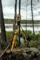
We employ GPS systems, UAV drones, robotic total stations, and traditional methods to ensure precise measurements for diverse surveying projects.
Can you help with historical property research?
Our archives include survey records from 1888 onward, providing valuable historical data for resolving boundary disputes and property research needs.