Business Details
34 Years
experience
Expert Land and Marine Surveying Services in Florida
Land & Sea Surveying has been a leader in multi-disciplinary surveying services since 1992, combining cutting-edge technology with deep industry expertise. Our team of licensed surveyors, technicians, and specialists delivers precise data and actionable insights to support critical project decisions. With over a century of combined experience, we serve diverse sectors including government, energy, and environmental management. Our founder, Tim Carlile, a professional surveyor licensed in six states and a USCG/FAA-certified operator, has driven technological innovation since 1976. We maintain rigorous quality standards through continuous investment in advanced equipment and staff development.Our services span hydrographic, land, and drone surveying, supported by long-term contracts with major agencies like Port Canaveral. As a certified veteran-owned small business, we prioritize accuracy, reliability, and client satisfaction. Our technical capabilities include boundary surveys, bathymetric mapping, and subsurface utility detection. We adhere to federal and state compliance requirements while delivering tailored solutions for complex projects. This commitment to excellence has established us as one of Florida's most technologically advanced surveying firms.
Services
Hydrographic Surveying
Land Surveying
Drone Surveying
Subsurface Utility Location
Construction Layout Surveys
Boundary Surveys
Topographic Mapping
Bathymetric Surveys
Magnetometer Surveys
Sub-Bottom Profiling
Details
- Year established: 1992
Highlights and features
- We have over 100 years of combined experience in surveying
- We maintain six state surveyor licenses and multiple federal certifications
- Our team includes FAA-licensed drone pilots and USCG captains
- We hold long-term service contracts with major government agencies
- We are certified as a veteran-owned small business in Florida
Associations and certifications
- HYPACK Certified Hydrographer
- Florida Board of Professional Surveyors
- Federal Aviation Administration (FAA)
- United States Coast Guard (USCG)
Services
Hydrographic Surveying
We conduct detailed underwater mapping using multibeam and singlebeam sonar systems. Our services support dredging projects, marine construction, and environmental assessments. Clients receive precise bathymetric data and seabed imagery for coastal and offshore developments.
Drone Surveying
Our FAA-certified pilots operate advanced drones for topographic mapping and 3D modeling. This technology provides rapid data collection for large areas with 3cm accuracy. Applications include beach renourishment projects and military infrastructure assessments.
Land & Sea Surveying
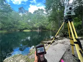
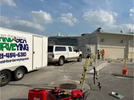
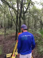
We perform boundary determination, construction layout, and topographic surveys using robotic total stations and RTK GPS. Our services support real estate development, utility projects, and government infrastructure with legally defensible documentation.
Subsurface Utility Location
Using ground penetrating radar and electromagnetic locators, we identify underground utilities for construction projects. Our vacuum excavation methods confirm precise utility locations to prevent damage during excavation activities.
Construction Surveys
We provide precise stakeout and as-built surveys for construction projects. Our services ensure proper alignment of infrastructure elements and documentation of completed works for engineering and regulatory requirements.
People
Tim Carlile
Founder and President
With 44 years of experience, Tim Carlile is a licensed surveyor in six states and a USCG captain. He oversees all operations and quality control at Land & Sea Surveying, driving technological innovation since founding the company in 1992.
Suzanne Carlile
Office Manager
Suzanne Carlile manages financial operations and project coordination with 14 years of corporate accounting experience. She also operates hydrographic survey systems and CAD software for data processing and drafting.
Scott Sharpe
Hydrographic Specialist
Scott Sharpe brings 25 years of ocean engineering expertise to hydrographic surveys. He manages data collection with multibeam systems and has participated in over 125 oceanographic cruises for marine research and mapping projects.
Michael Carlile
CAD Manager
Michael Carlile handles drafting and design using AutoCAD and Terramodel. With experience in GPS systems and hydrographic surveys, he supports both field operations and office data processing for survey projects.
Timothy Carlile
Lead Survey Technician
Timothy Carlile has six years of field experience with RTK GPS and multibeam systems. He captains survey vessels and processes hydrographic data while continuing his education in geomatics and drafting technology.
Questions
What surveying services do you offer?
We provide hydrographic, land, drone, boundary, topographic, and construction surveys using advanced technology for precise geospatial data.
Which areas do you serve?
We operate throughout Florida including Port Canaveral, Sebastian Inlet, Brevard County, and Suwannee River Water Management District.
What technology do you use?
Our equipment includes multibeam sonar, RTK GPS, robotic total stations, and FAA-certified drones like the WingtraOne and DJI Phantom 4 Pro.
How experienced is your team?
Our staff has over 100 years combined experience with six state surveyor licenses, USCG captain certifications, and FAA drone pilot credentials.
Are you a certified business?
We are a Florida-registered professional surveying firm and certified veteran-owned small business with South Florida Water Management District.
What government contracts do you hold?
We maintain continuing service contracts with Port Canaveral since 2015 and Sebastian Inlet District since 2004.