Business Details
50+ Years
experience
Expert Land Surveyors in Lebanon, PA
Established in 1948, our firm has built a reputation for delivering precise and reliable engineering and land surveying services across Lebanon County and surrounding areas. With over 75 years of combined experience, our team utilizes cutting-edge technology such as GPS and AutoCAD to ensure accuracy and efficiency in every project. We specialize in property surveys, topographical mapping, flood elevation studies, and construction stakeout, serving residential, commercial, industrial, and municipal clients.Our acquisition by Chrisland Engineering in 2023 has expanded our capabilities, integrating multidisciplinary expertise in civil and structural engineering. We pride ourselves on fostering long-term relationships through transparent communication, technical excellence, and a commitment to community development. Our field crews and office staff work cohesively to provide tailored solutions that meet the unique needs of each client, ensuring projects are completed on time and to the highest standards.

Services
Land Subdivision Design
Topographical Surveys
Property Surveys
Storm Water Management
Percolation Tests
Flood Insurance Studies
Construction Stakeout
Sewage Disposal Design
Details
- Year established: 1948
Highlights and features
- We offer 75+ years of combined experience in land surveying and engineering.
- Our team uses advanced GPS and AutoCAD technology for accurate results.
- We serve diverse sectors including residential, commercial, and municipal projects.
- Our partnership with Chrisland Engineering expands our multidisciplinary expertise.
- We prioritize transparent communication and client-focused solutions.
Services
Land Subdivision Design
We specialize in land subdivision planning, creating precise layouts for residential, commercial, and agricultural developments. Our team ensures compliance with local regulations while optimizing land use for clients. With decades of experience in Lebanon County, we deliver efficient solutions that balance practicality and legal requirements.
Topographical Surveys
Our topographical surveys capture detailed elevation data and natural features to support construction and development projects. Using advanced GPS technology, we provide accurate 3D models of properties. This service helps clients understand terrain challenges and plan infrastructure effectively.
Flood Insurance Studies
We conduct flood elevation studies to determine insurance requirements and mitigate risk for property owners. Our certified surveyors measure base flood elevations with precision, ensuring compliance with FEMA standards. This service supports accurate insurance ratings and floodplain management.
Construction Stakeout
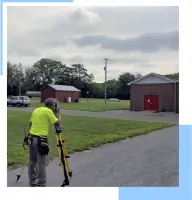
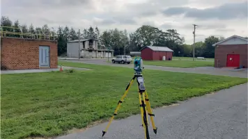
Our construction stakeout service marks precise locations for buildings, roads, and utilities based on engineering plans. Using electronic total stations, we ensure alignment and grading accuracy. This critical service minimizes errors and delays during development projects.
Percolation Tests
We perform soil percolation tests to evaluate drainage capabilities for septic system installations. Our registered sewage enforcement officers analyze soil composition and absorption rates, providing data-driven recommendations. This service ensures compliant and sustainable wastewater solutions.
People
R. Scott Carpenter
Soils Department Head
R. Scott Carpenter oversees our soils department, specializing in sewage disposal system design. With prior experience collaborating with the Pennsylvania Department of Environmental Protection, he ensures innovative and compliant wastewater solutions for residential and commercial clients.
Questions
What services does Matthew & Hockley Associates offer?
We provide land surveying, engineering, topographical mapping, flood elevation studies, construction stakeout, and sewage disposal design for residential, commercial, and municipal projects.
How long has the company been in business?
Founded in 1948, we have over 75 years of combined experience in land surveying and engineering services in Lebanon County, Pennsylvania.
What areas do you serve?
We primarily serve Lebanon County, Pennsylvania, and surrounding regions, supporting local and regional development projects.
What technology do you use for surveys?
Our field crews use GPS, electronic total stations, and AutoCAD software to ensure accurate and efficient data collection and project delivery.
Are your team members certified professionals?
Yes, our team includes registered surveyors, licensed engineers, and certified sewage enforcement officers with extensive industry expertise.