Business Details
30 Years
experience
Professional Land Surveying Services in PA & NY
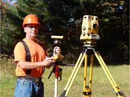
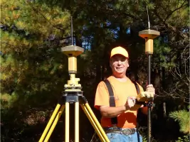
Cox Surveying has been providing professional land surveying services since 1996, serving clients across Pennsylvania and New York. Founded by John Cox, a licensed surveyor and U.S. Army veteran, we specialize in residential, commercial, and industrial surveying with a commitment to precision and integrity. Our process begins with thorough deed research and client consultation, followed by advanced fieldwork using GPS and robotic total stations to ensure accuracy within 0.01 feet. We offer boundary surveys, subdivisions, construction layout, topographic mapping, FEMA elevation certificates, and oil well location services. All work adheres to strict professional standards, with final maps delivered upon client request.Our team maintains memberships in the Pennsylvania Society of Land Surveyors and the New York State Association of Professional Land Surveyors, reflecting our dedication to industry excellence. With over 25 years of experience, we prioritize clear communication, transparent pricing, and timely project completion. Our equipment investments in survey-grade GPS and electronic measuring tools ensure reliable results for every client. We operate under signed contracts guaranteeing fixed pricing and professional execution, with no hidden fees. Located in Lewis Run, Pennsylvania, we serve McKean, Warren, Elk, Cattaraugus, and surrounding counties, offering free quotes for all projects.
Services
Boundary Surveys
Subdivisions
Construction Layout
Topographic Surveys
FEMA Elevation Certificates
Oil Well Location
Global Positioning
Details
- Year established: 1996
Highlights and features
- Licensed surveyors in Pennsylvania and New York since 1996
- U.S. Army veteran-owned business with military precision standards
- Uses survey-grade GPS accurate to 0.01 feet
- Fixed pricing guaranteed through signed contracts
- Free initial consultations and quotes for all projects
Associations and certifications
- Pennsylvania Society of Land Surveyors
- New York State Association of Professional Land Surveyors
Services
Boundary Surveys
We conduct precise boundary surveys to establish property lines using GPS and electronic measuring tools. Our process includes deed research, physical corner marking with 5/8" rebars, and line staking every 50-100 feet. Clients receive detailed maps showing exact property dimensions and legal descriptions.
Subdivisions
Our subdivision services include planning, zoning compliance, and legal documentation preparation. We coordinate with township offices and sewage enforcement officers to ensure regulatory approval. Final maps are recorded at courthouses for legal permanence and client reference.
Construction Layout
We provide accurate construction layout services for buildings and infrastructure. Using robotic total stations, we mark precise locations for foundations, utilities, and site improvements. Our work ensures projects meet zoning requirements and construction specifications with millimeter-level accuracy.
Topographic Surveys
Our topographic surveys document natural and man-made features with elevation data. We use advanced GPS and data collection software to create detailed terrain models. These surveys support engineering designs, drainage planning, and environmental assessments for development projects.
FEMA Elevation Certificates
We prepare FEMA elevation certificates for flood insurance requirements. Our surveys measure building elevations relative to flood zones using precise leveling equipment. These certified documents help property owners obtain accurate flood insurance rates and comply with local regulations.
People
John Cox
Owner & Licensed Surveyor
John Cox has operated Cox Surveying since 1996, providing land surveying services across Pennsylvania and New York. A U.S. Army veteran and licensed surveyor in both states, he combines military precision with over 25 years of field experience. John specializes in boundary resolution, construction layout, and subdivision planning using advanced GPS technology.
Questions
What surveying services do you offer?
We provide boundary surveys, subdivisions, construction layout, topographic mapping, FEMA elevation certificates, and oil well location services using advanced GPS technology.
How long does a typical survey take?
The process includes 2-3 hours of initial research followed by fieldwork. Completion time varies based on project complexity and scheduling, with work completed in order of receipt.
Do you serve areas outside Pennsylvania?
Yes, we serve New York and Pennsylvania counties including McKean, Warren, Elk, and Cattaraugus with licensed surveying services.
Is there a charge for quotes?
No, we provide free consultations and written quotes with no obligation for all surveying projects.
What equipment do you use?
We use survey-grade GPS accurate to 0.01 feet, robotic total stations, theodolites, and advanced data collection software for precise measurements.
Are your surveys legally recognized?
Yes, our surveys meet professional standards and can be recorded at courthouses for legal documentation purposes.