
Business Details
50+ Years
experience
Your Trusted Partner for Land Surveying and GIS Solutions
Founded in 1954, Cinquini & Passarino has built a legacy of excellence in land surveying, geographic information systems (GIS), and hydrography. Our firm serves developers, contractors, engineers, property owners, and government agencies across the Bay Area and beyond. With over 70 years of combined experience, our team of licensed professionals utilizes cutting-edge technology to deliver precise and reliable surveying solutions. We specialize in construction staking, boundary surveys, topographic mapping, and ALTA surveys, ensuring projects meet regulatory standards and client expectations. Our GIS department integrates spatial data into actionable insights, while our hydrography division conducts bathymetric surveys for coastal and inland water projects.Headquartered in Santa Rosa, California, we maintain offices in Healdsburg, Napa, and Oakland to better serve regional clients. Our commitment to accuracy, innovation, and client collaboration has solidified our reputation as a trusted leader in the surveying industry. We prioritize clear communication, technical expertise, and tailored solutions to address the unique challenges of each project. From initial planning to final execution, Cinquini & Passarino delivers results that uphold the highest standards of professionalism and integrity.
Services
Land Surveying
Railroad Surveying
Construction Staking
Hydrography
GIS Mapping
Details
- Year established: 1954
Highlights and features
- We offer 70 years of experience in land surveying and hydrography.
- Our team utilizes the latest technology for accurate survey results.
- We serve a diverse client base including government agencies and developers.
- Our dedicated GIS department delivers tailored spatial data solutions.
- We maintain offices in four Northern California locations for regional accessibility.
Services
Land Surveying
Our land surveying services encompass boundary determination, topographic mapping, and ALTA surveys for residential, commercial, and infrastructure projects. Using advanced equipment, we ensure compliance with legal standards and provide precise data for property development. Clients benefit from our expertise in resolving boundary disputes and supporting construction planning.
GIS Mapping
We develop customized GIS solutions by integrating authoritative spatial datasets with client-specific requirements. Our team creates interactive maps, 2D/3D visualizations, and tabular data to support decision-making for urban planning, environmental management, and infrastructure projects. Deliverables are compatible with CAD systems and mobile applications for field use.
Hydrography
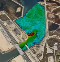
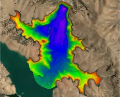
Our hydrography division specializes in underwater mapping for reservoirs, harbors, and coastal areas. Using multibeam sonar technology, we conduct dredge monitoring, habitat restoration assessments, and construction surveys. Clients receive detailed depth measurements and seabed analysis to support marine and freshwater projects.
Construction Staking
We provide precise staking for residential subdivisions, roadways, and utility installations. Our surveyors collaborate with contractors to mark critical points for grading, foundations, and infrastructure. This ensures alignment with design plans and minimizes costly rework during construction phases.
Railroad Surveying
Our railroad surveying services include alignment verification, right-of-way mapping, and corridor assessments. We support rail operators and contractors with data for maintenance, expansion, and safety compliance. Surveys are conducted using high-accuracy instruments to meet industry-specific tolerances.
People
James M. Dickey
Principal
James M. Dickey is a licensed Professional Land Surveyor with extensive expertise in project management and boundary analysis. He oversees survey operations and ensures technical excellence across all client engagements.
Anthony G. Cinquini
Principal
Anthony G. Cinquini, a licensed Professional Engineer and Land Surveyor, contributes decades of experience in land development and infrastructure projects. He focuses on strategic growth and technical innovation for the firm.
Mark P. Andrilla
Managing Project Surveyor
Mark P. Andrilla leads complex survey projects with a focus on accuracy and client satisfaction. His engineering and surveying background ensures seamless integration of field data with design requirements.
Derek J. Clark
Professional Land Surveyor
Derek J. Clark specializes in boundary surveys and legal descriptions. His attention to detail supports clients in resolving property disputes and meeting regulatory compliance.
Jimmy R. Kulpa
Chief Hydrographer
Jimmy R. Kulpa directs hydrographic operations, utilizing advanced sonar technology for underwater mapping. His expertise ensures precise data collection for marine and environmental projects.
Questions
What services does Cinquini & Passarino offer?
We provide land surveying, GIS mapping, hydrography, construction staking, and railroad surveying services for public and private sector clients.
How long has the company been in business?
Cinquini & Passarino has operated since 1954, offering over 70 years of surveying expertise in Northern California.
Do you serve clients outside the Bay Area?
While based in Santa Rosa, we serve clients throughout California, including Napa, Healdsburg, and Oakland regions.
What technologies do you use for surveys?
We employ GPS, total stations, multibeam sonar, and GIS software to ensure high-accuracy data collection and analysis.
Can you handle government project requirements?
Yes, we frequently work with local, state, and federal agencies, adhering to strict regulatory standards for public infrastructure projects.