Business Details
25 Years
experience
Expert Land Surveying Services in Miami
Founded in 2001 by Professional Surveyor and Mapper Juan A. Suarez, Jr., our firm has built a reputation for excellence in land surveying across South Florida. With over two decades of industry experience, we specialize in delivering precise boundary surveys, topographic mapping, and construction documentation while maintaining unwavering commitment to client satisfaction. Our team combines technical expertise with ethical business practices, ensuring every project meets the highest standards of accuracy and compliance. We pride ourselves on rapid turnaround times without compromising quality, having completed thousands of surveys for residential, commercial, and governmental clients.Our services extend beyond mere measurementswe provide comprehensive solutions that protect property rights, facilitate development, and support infrastructure growth. Backed by professional certifications and state licensing, we maintain active involvement in community development initiatives while adhering to strict environmental and safety standards. Client testimonials consistently highlight our reliability, technical proficiency, and exceptional customer service, making us a trusted partner for all surveying needs across Florida.
Services
Boundary Surveys
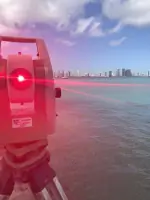
Topographic Surveys
ALTA Surveys
Elevation Certificates
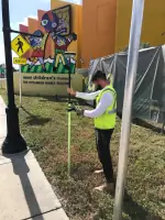
Construction Surveys
Stormwater Management
Roadway Design
ADA Compliance Assessments
Site Development
Drainage Recertifications
Details
- Year established: 2001
Highlights and features
- We offer 20+ years of professional surveying experience in South Florida
- Our team holds active Professional Surveyor and Mapper certifications
- We guarantee rapid turnaround times without compromising accuracy
- Licensed to service all Florida counties with state-approved equipment
- Client-focused approach with proven track record of on-time delivery
What people say
Fast service
Great customer service
Detailed survey
Reasonable price
Highly recommend
Services
Boundary Surveys
Our boundary surveys precisely determine property lines using advanced geodetic measurements. This service protects property rights by identifying exact parcel dimensions and resolving boundary disputes. Clients receive detailed documentation meeting all state requirements for title insurance and real estate transactions.
Elevation Certificates
We provide FEMA-compliant elevation certificates that document building elevations relative to flood zones. These critical documents enable accurate flood insurance rate calculations and ensure compliance with local building codes for properties in South Florida's coastal areas.
Topographic Surveys
Our topographic surveys create detailed 3D maps showing natural and man-made features. This data supports engineering designs, drainage planning, and construction projects by providing accurate elevation models and terrain analysis for development sites.
Construction Surveys
We conduct precise construction surveys for new developments, including stake-out positioning and as-built documentation. Our services ensure proper building placement, verify construction progress, and maintain compliance with approved site plans throughout the development process.
ALTA Surveys
Our ALTA/ACSM surveys meet the highest industry standards for commercial property transactions. These comprehensive surveys include boundary verification, easement identification, and improvements documentation required by title companies for major real estate deals across Florida.
People
Juan A. Suarez, Jr.
Founder / Professional Surveyor and Mapper
With over 20 years of experience, Juan established the company in 2001 after graduating from Florida International University. He holds active PSM certification and oversees all surveying operations while maintaining hands-on involvement in complex projects.
Questions
Why is a property survey necessary?
A survey protects your property rights by clearly defining boundaries, identifying encroachments, and ensuring you receive legal ownership of the land you purchase.
What is an elevation certificate used for?
Elevation certificates determine flood insurance rates by documenting building elevations relative to FEMA flood zones, required for coastal properties in Florida.
Do you service areas outside Miami?
We provide surveying services throughout all Florida counties, supporting residential, commercial, and government clients statewide.
How quickly can I get survey results?
We guarantee timely delivery based on client deadlines, with standard surveys typically completed within 48 hours of request.
What types of surveys do you offer?
We offer boundary, topographic, ALTA, elevation, construction, and specific-purpose surveys tailored to residential, commercial, and infrastructure projects.