Halliburton Surveying & Mapping, LLC (HSM) utilizes surveying's most advanced technologies available to collect the critical measurements and evidence needed when assisting our Clients. It is our utmost goal to efficiently create accurate surveys on time and within your budget. Our projects include residential, commercial, and industrial properties.
The foundation of our company is based on traditional land surveying services. However, we do sub-specialize in land-boundary determination, 3D laser scanning, Aerial Drone Mapping, Global Positioning System (GPS) surveys, custom mapping, and deformation monitoring. Although licensed as a professional land surveyor in multiple states, our primary focus is within the North Alabama region, including the Greater Huntsville area.
Whether your projects are in the pre-construction, construction, or post-construction phases, HSM has the tools and personnel to help make your next project a success.
Services
About Us
Report
The Halliburton Surveying & Mapping, LLC founding member, Troy Halliburton, serves as the company's Principle Land Surveyor.
Troy received his Bachelor of Science degree in Land Surveying and Mapping Science from East Tennessee State University.
He has 23 years of diverse surveying experience throughout the Southeast on hundreds of projects.
He is currently licensed in Alabama and Tennessee.
Troy has previously served as Secretary/Treasurer for Alabama Society of Professional Land Surveyors.
He has also presented Professional Development Hours and Continuing Education courses on a variety of topics, including Land Surveying, 3D Laser Scanning, and Deformation Monitoring.
Recent Projects
Report
Over the past seven years in business, we have been fortunate to represent a number of interesting and challenging projects.
Provided miscellaneous construction layout services, control and existing surveys for MTMUS and three other onsite Tier 1 suppliers.
We're working for 5 different general and subcontractors onsite.
Provided multiple boundary and topographic surveys, legal descriptions, and other project assistance as needed, located on and off site of the Nissan Motor Manufacturing Company's property.
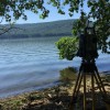
3D Laser Scanning
Report
Integrating 3D Laser Scanning technology into project workflows has been proven to compress schedules, lower re-work, and cost savings.
For years, the technology was thought to be too expensive, slow, and cumbersome.
However, recent advancements in both software and hardware technologies have enabled laser scanning to become a major benefit when integrated.
3D Laser Scanning enables the Surveyor to rapidly map the surfaces of most objects.
Regardless of the project size, 3D Laser Scanning may be the best tool for the project.
Deformation Monitoring
Report
Deformation monitoring is the systematic measurement and tracking of the alteration in the shape or dimensions of an object as a result of stresses induced by applied loads.
Localized subsidence may suddenly become evident by visible cracking, slope failures, and/or malfunctioning equipment.
Oftentimes, a Client may not even be aware of the hazardous conditions that lie below the surface.
Monitoring continued movements is critical to ensure stability and structural integrity.
Monitoring can also confirm projected movements which can further help to ensure client and/or public safety.
Mapping Services
Report
A land survey may not be necessary to fulfill mapping needs.
Clients may only need a simple representation of their property.
Examples may be for Auction Exhibits, Road Frontage Signs, Preliminary Planning, and more.
These maps can typically be made at attractive prices.
HSM maps include many of the popular public hunting and fishing areas in Eastern Arkansas.
The maps are standard 24" x 36", one side laminate.
High resolution aerial photography shows access points, boat ramps, trails, and much more.
Reviews

Be the first to review Halliburton Surveying & Mapping.
Write a Review