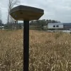
Browse 2 surveying businesses serving Huntsville, AL, from residential boundary specialists to firms handling commercial development surveys. Review their services and customer feedback, then contact suitable surveyors for project details and estimates.

Halliburton Surveying & Mapping provides high-precision land surveying, LiDAR scanning, and mapping services for commercial, industrial, and municipal clients. With expertise in deformation monitoring and utility locating, we deliver tailored solutions using cutting-edge technology. Our team of licensed surveyors and FAA-certified drone pilots ensures accuracy and efficiency across diverse projects.
Land Surveying
LiDAR/Laser Scanning
Mapping Services
Huntsville Land Surveying provides professional boundary, topographic, and elevation survey services in Madison County, Alabama. Our licensed surveyors use advanced GPS and drone technology to deliver accurate property measurements for residential and commercial clients. We specialize in ALTA surveys, flood zone determinations, and construction site mapping to support real estate transactions, insurance requirements, and development projects.
ALTA Survey
Boundary Surveying
Construction Survey