Business Details
22 Years
experience
Expert Land Surveying & GIS Services in Reno, NV
Since 2004, US Geomatics has been a trusted provider of land surveying, geographic information system (GIS), and water rights management services across the western United States. Headquartered in Reno, Nevada, our team combines technical expertise with personalized service to meet the needs of commercial and industrial clients. We specialize in boundary research, utility surveys, water rights mapping, and large-scale project management, utilizing advanced technologies such as aerial drones and custom-developed software applications. Our FAA-licensed drone operations enhance data collection efficiency while maintaining precision. With decades of collective GIS experience, we deliver base mapping, flood modeling, and utility route planning solutions tailored to complex infrastructure projects. Our professionals are actively engaged in industry associations, including the Nevada Association of Land Surveyors and the Nevada Water Rights Association, ensuring adherence to best practices and regulatory standards.We have supported critical initiatives such as the Truckee Meadows Water Authority's 2005-2025 Facility Plan and the NEAC Transmission Routing Project, demonstrating our capacity to manage multi-state, high-impact assignments. Our commitment to client collaboration is evident in our boutique-style approach, where dedicated attention is given to every project from initial planning to final deliverables. By integrating field data acquisition, topographic mapping, and legal documentation services, we provide comprehensive solutions that align with both technical and regulatory requirements.
Services
Land Surveying
GIS Services
Water Rights Management
Drone Surveying
Project Management
Utility Surveys
Mapping Services
Data Collection
Transmission Routing
Solar Well Pumping
Details
- Year established: 2004
Highlights and features
- We have over 20 years of geographic information system experience.
- Our team holds FAA licensing for drone survey operations.
- We provide personalized service for large-scale industrial projects.
- We develop custom software applications for unique mapping challenges.
- Our professionals maintain active memberships in six regional surveying associations.
Associations and certifications
- FAA
Services
Land Surveying
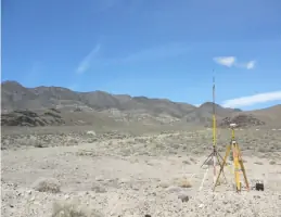
Our land surveying services encompass boundary research, topographic mapping, and legal documentation for commercial and industrial projects. Using GPS technology and FAA-licensed drones, we deliver precise measurements for property development, infrastructure planning, and regulatory compliance. Our team manages complex assignments including right-of-way acquisitions and utility coordination.
GIS Services
We provide comprehensive GIS services from data entry to full system implementation. Our capabilities include base mapping, flood modeling, utility route planning, and custom application development. We maintain and update spatial databases for water authorities and support transmission infrastructure projects with accurate geospatial analysis.
Water Rights Management
Specializing in Nevada's prior appropriation doctrine, we handle water rights transfers, ownership documentation, and usage claims. Our licensed surveyors assist agricultural and industrial clients with legal compliance, filing transfer maps, and managing water allocation for large-scale operations across the state.
Drone Surveying
Our FAA-licensed drone operations enhance survey accuracy while reducing field time. We conduct aerial data collection for topographic mapping, construction monitoring, and environmental assessments. This technology enables safe access to challenging terrain while maintaining high-resolution data capture for engineering and infrastructure projects.
Project Management
We provide end-to-end project management for surveying and GIS initiatives. Our services include personnel supervision, budget coordination, and technical documentation. We oversee data acquisition, legal description preparation, and utility mapping for design-build projects, ensuring timely delivery of complex infrastructure developments.
Questions
What geographic areas do you serve?
We operate across Nevada, California, Arizona, Utah, Oregon, and Washington, with headquarters in Reno, Nevada.
What industries benefit from your services?
Our clients include commercial developers, industrial operators, utility companies, and government agencies requiring surveying and spatial data solutions.
How do you handle complex water rights issues?
We specialize in Nevada's water law, providing transfer documentation, ownership mapping, and regulatory compliance services for agricultural and industrial clients.
What technologies do you use for surveying?
We employ GPS systems, FAA-licensed drones, and custom-developed software applications to enhance accuracy and efficiency in data collection.
Can you manage large-scale infrastructure projects?
Yes, we provide comprehensive oversight for multi-phase developments, including the Truckee Meadows Water Authority's facility planning and NEAC transmission routing studies.