Business Details
33 Years
experience
Trusted Land Surveyors in Monterey, CA
Central Coast Surveyors has been a trusted provider of professional land surveying and mapping services in the Monterey Bay area since 1993. With over 35 years of combined experience, our team specializes in delivering precise and efficient solutions for residential, commercial, and public sector projects. Our expertise spans topographic surveys, boundary determinations, construction staking, and ALTA/NSPS Land Title Surveys, serving industries including real estate, engineering, and environmental planning. Licensed in both California and Hawaii, we prioritize clear communication and rapid project turnaround while maintaining the highest standards of accuracy.From small residential plots to large-scale developments like hospitals and retail centers, we combine advanced GPS technology with decades of local knowledge to meet client needs across Monterey, Santa Cruz, and Hollister. Our commitment to excellence extends to specialized services such as FEMA Elevation Certificates, which help property owners navigate flood insurance requirements with confidence.
Services
Topographic Surveys
Construction Surveys
ALTA/NSPS Surveys
Boundary Surveys
FEMA Certificates
Details
- Year established: 1993
Highlights and features
- We offer 35+ years of local land surveying expertise in Monterey County
- Our team holds active licenses in both California and Hawaii
- We deliver rapid turnaround times for all surveying projects
- We utilize cutting-edge GPS technology for enhanced accuracy
- Our staff maintains direct communication with clients throughout projects
Services
ALTA/NSPS Land Title Surveys
We conduct ALTA/NSPS standard surveys for commercial and residential properties, meeting title insurance requirements through precise boundary determination and mapping. Our licensed surveyors deliver accurate documentation for property transactions while adhering to national standards. Clients receive detailed reports that satisfy lender and title company requirements across California and Hawaii.
Boundary Surveys
Our boundary surveys establish clear property lines using historical records and modern technology. This service supports fencing installations, landscaping projects, and property dispute resolution. We provide legal documentation that meets county recording standards while maintaining 35+ years of Monterey County-specific expertise in boundary determination.
Topographic Surveys
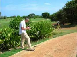
We create detailed elevation models and terrain maps for development projects using advanced GPS equipment. These surveys support engineering designs, environmental assessments, and construction planning. Our digital deliverables integrate with CAD systems for seamless project implementation across residential, commercial, and public works applications.
Construction Surveys
Our construction staking services ensure accurate project implementation through physical marker placement and elevation verification. We support residential developments, infrastructure projects, and commercial buildings with layout services that maintain compliance with approved plans. Real-time GPS technology improves efficiency while reducing field time costs for contractors.
FEMA Elevation Certificates
We provide FEMA Elevation Certificates to determine flood insurance requirements for properties in Monterey and Carmel Valley regions. Our surveys measure building elevations relative to floodplain data, helping property owners establish insurance premiums and compliance with NFIP regulations. This service includes detailed documentation for lender and municipal requirements.
Questions
What surveying services do you offer?
We provide ALTA/NSPS land title surveys, boundary surveys, topographic mapping, construction staking, and FEMA elevation certificates for residential, commercial, and public sector clients.
Which areas do you serve?
Our primary service area includes Monterey Bay, Santa Cruz, and Hollister. We also hold active surveying licenses in Hawaii for projects across the islands.
How long have you been in business?
Central Coast Surveyors has provided land surveying services since 1993, maintaining continuous operations with the same leadership team for over 30 years.
Are you licensed professionals?
Yes, we hold active California Land Surveyor License #LS4974 and Hawaii Land Surveyor License #LS11860, ensuring compliance with state-specific regulations and standards.
What's your typical project turnaround time?
We prioritize rapid response and completion, typically delivering standard surveys within 3-5 business days depending on project complexity and site conditions.
Do you handle both residential and commercial projects?
Yes, our experience spans from single-family home surveys to large-scale commercial developments including hospitals, retail centers, and public infrastructure projects.