Access to forward-thinking technology and leading-edge equipment is only the beginning of the standard setting service that each of our clients can expect when they partner with us. Our exceptionally high performing staff sets the bar on production and delivers quality work at every turn. Plus, we like getting a little dirt on our boots and we'll go above and beyond to ensure that every project we undertake is on point.
Remote Sensing/LiDAR Just when we thought surveying couldn't get any cooler, we posted job openings for "pilots." Subsurface Utility Location Knowing what's below is essential to every land improvement, and we're the best in our field. Land Development Services Commercial and residential land development is the cornerstone of our business and our performance is on point.
Construction Support Services With the engineer or architect's plan in hand, we hit the ground running. Hydrographic Surveys While most survey companies stick with dry land, we've never been afraid of getting a little wet.
Services
Who We Are
Report
Regardless of the level of complexity of each project, we meet and exceed our client's expectations.
Our dedication to provide the best surveying and mapping services is evident in the overwhelming number of return clients that rely on us to carry on past projects and complete new projects.
At the foundation of our company's values is our strong dedication to provide quality professional services.
We are attentive to each and every project requirement.
Our survey procedures and review standards are proven to ensure quality from project onset to completion.
What We Do
Report
Commercial and residential land development is the cornerstone of our business and our performance is on point.
We love getting in the dirt and helping raise up the next building, community, or point of interest in every area we serve.
With an assembly of every leading-edge technology in our field and a team of crews specialized in all aspect our business, we will exceed your expectations at every level of our work from boundary, design and as-built surveys, to platting and construction staking.
Remote Sensing/LiDAR
Report
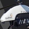
Remote Sensing/LiDAR Just when we thought surveying couldn't get any cooler, we posted job openings for "pilots."
Just when we thought surveying couldn't get any cooler, we posted job openings for "pilots."
And with a cadre of the latest technology in UAS photogrammetry, top of the line long range, high-definition LiDAR scanning systems and industry standard software, our team of FAA certified pilots has developed our remote sensing services department into a leader in our industry.
No matter the topography or obstacles on the ground, our advanced hyperspectral imaging systems will deliver quick-turn around, high resolution scans with clarity and accuracy that are on point.
Subsurface Utility Location
Report
Subsurface Utility Location Knowing what's below is essential to every land improvement, and we're the best in our field.
We've invested in a forward-thinking subsurface utility engineering team with a full toolbox of technology and capabilities to make us the best in our field.
Whether we are applying air and hydro vacuum excavating, electromagnetic locating, ground penetrating radar, asset mapping or foundation/structure clearing, you can be certain that the project you're about to build out is on point.
Land Development Services
Report
Land Development Services Commercial and residential land development is the cornerstone of our business and our performance is on point.
Commercial and residential land development is the cornerstone of our business and our performance is on point.
We love getting in the dirt and helping raise up the next building, community, or point of interest in every area we serve.
With an assembly of every leading-edge technology in our field and a team of crews specialized in all aspect our business, we will exceed your expectations at every level of our work from boundary, design and as-built surveys, to platting and construction staking.
Reviews

Be the first to review Geopoint Surveying.
Write a Review