Business Details
11 Years
experience
Expert Land Surveying Services in Tahoe City, CA
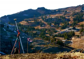
At TerraGraphic Land Surveying, we pride ourselves on delivering high-quality land surveying services with a commitment to precision, technology, and client satisfaction. Our team, led by California Professional Land Surveyor Travis Pachacki, brings extensive experience across Northern California, including the rugged terrains of Lake Tahoe, Truckee, and the Sierra foothills. We utilize state-of-the-art technology to streamline every project, ensuring efficiency and cost-effectiveness while maintaining the highest standards of accuracy. Our process emphasizes attention to detail, incorporating features that aid design professionals in saving time and resources for our clients. With a focus on prompt communication, we guarantee timely responses to inquiries and proposals delivered within 24 hours.Recognizing the importance of fast turnaround times in regions with limited building seasons, we prioritize expediting survey deliverables without compromising quality. Our transparent pricing model operates on a fixed-fee basis, with all costs disclosed upfront and no hidden fees. We offer diverse payment options, including cash, check, credit cards, PayPal, and Bitcoin, to ensure convenience for our clients. Our dedication to excellence has earned us strong partnerships with engineering firms and repeat business from satisfied clients. With over a decade of service since our founding in 2015, we continue to build a reputation as a trusted partner for land surveying needs in Northern California and beyond.

Services
Land Surveying
Boundary Surveys
Topographic Surveys
Design Documents
Permitting Support
Details
- Year established: 2015
Highlights and features
- We offer licensed land surveyors handling every project step from start to finish.
- Our team has extensive experience in Northern California's diverse terrain.
- We utilize state-of-the-art technology to streamline surveys and reduce costs.
- Our detailed surveys include features that save design professionals time and money.
- We guarantee fast turnaround times crucial for Sierra's limited building season.
What people say
Professional, timely
Accurate, timely and cost effective
Great product
Detailed and on time
Energetic and smart
Services
Land Surveying
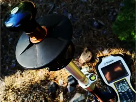
Our land surveying services provide precise measurements and boundary determinations for residential, commercial, and infrastructure projects. Using advanced GPS and 3D mapping technology, we deliver accurate data essential for property development, legal documentation, and construction planning. Our surveys meet all state and federal standards, ensuring reliability for permits and engineering designs.
Boundary Surveys
Boundary surveys establish property lines and identify easements or encroachments. We conduct thorough research of historical records and use high-precision equipment to mark boundaries with exceptional accuracy. This service is critical for real estate transactions, land development, and resolving property disputes, providing legally defensible documentation for homeowners and businesses.
Topographic Surveys
Topographic surveys create detailed elevation models of land surfaces, including natural and man-made features. Our digital mapping techniques produce contour lines and 3D models used for engineering design, environmental assessments, and construction planning. These surveys help architects and engineers optimize site layouts while minimizing environmental impact.
Design Documents
We prepare comprehensive design documents integrating survey data with engineering requirements. These plans include site layouts, grading specifications, and utility locations tailored to local permitting standards. Our documents streamline approval processes for building permits and infrastructure projects, reducing delays and ensuring compliance with regulatory agencies.
Permitting Support
Our permitting support ensures survey deliverables meet all local agency requirements for development approvals. We collaborate directly with planning departments to address technical questions and expedite submissions. This service reduces administrative hurdles for clients, accelerating project timelines while maintaining adherence to zoning laws and environmental regulations.
People
Travis Pachacki
Owner
Travis Pachacki is a California-licensed land surveyor with over a decade of experience in Northern California's challenging terrains. He founded TerraGraphic Land Surveying in 2015 to provide precise, technology-driven surveying solutions. His expertise in boundary determination, topographic mapping, and regulatory compliance has earned trust among engineering firms and property developers. Travis prioritizes direct client communication and fast project turnaround times.
Questions
What types of land surveying services do you offer?
We specialize in boundary surveys, topographic mapping, design documents, and permitting support for residential, commercial, and infrastructure projects across Northern California.
How do you ensure survey accuracy?
We use state-of-the-art GPS and 3D mapping technology, combined with Travis Pachacki's expertise as a licensed land surveyor, to deliver measurements meeting all regulatory standards.
Do you work outside the Sierra region?
While we focus on Lake Tahoe, Truckee, and Sierra foothills, our services extend to other Northern California areas, adapting to diverse terrains and project requirements.
What payment methods do you accept?
We accept cash, check, credit cards, PayPal, and Bitcoin for your convenience, with transparent fixed-fee pricing disclosed upfront.
How quickly can you complete a survey?
We prioritize fast turnaround times, especially during short building seasons, typically delivering proposals within 24 hours and final surveys based on project complexity.
How do I request a free estimate?
Visit our website or contact Travis directly at (530) 318-1761 to discuss your project details and receive a customized estimate within 24 hours.